Article citation information:
Marcisz, M., Sokołowski, S. Influence of
surrounding terrain morphology at Gliwice-Trynek
aerodrome on flight operations based on a 3D model of aerodrome approach areas.
Scientific Journal of Silesian University
of Technology. Series Transport. 2026, 131,
121-136. ISSN: 0209-3324. DOI: https://doi.org/10.20858/sjsutst.2026.131.7
Marek MARCISZ[1],
Szymon SOKOŁOWSKI[2]
INFLUENCE OF SURROUNDING TERRAIN MORPHOLOGY AT GLIWICE-TRYNEK AERODROME
ON FLIGHT OPERATIONS BASED ON A 3D MODEL OF AERODROME APPROACH AREAS
Summary. In this paper, the potential applications of 3D modeling of aerodrome approach areas and their significance
for the precise representation of the aerodrome environment are presented. The
findings indicate that UAV photogrammetry constitutes an efficient method for
monitoring adjacent areas, enabling the analysis of topography’s impact on the
safety and efficiency of flight operations. Integrating 3D terrain models with
navigation systems enhances the situational awareness of operational personnel.
Specifically, the study identified critical terrain hazards: tree stands near
thresholds 08 and 10 necessitating steeper climbs and posing bird-strike risks;
a Venturi effect between the southern waste-disposal site and warehouses
causing wind acceleration; and a nearby water reservoir contributing to fog and
solar glare. Implementing these 3D models into digital airspace management
addresses these immediate threats and supports the development of autonomous
UAV systems, increasing operational safety in regions with complex topography.
Keywords: UAVs, drones,
photogrammetry, 3D models
1. INTRODUCTION
Contemporary
history demonstrates an exceptionally dynamic development of unmanned aerial
vehicle (UAV) technologies, classified as emerging technologies that have
significantly revolutionized numerous socio-economic sectors. Initially
employed almost exclusively in military applications, UAVs are now widely used
in many civilian fields, including air transport, environmental monitoring,
precision agriculture, and geoinformatics.
Unmanned
aerial vehicles, equipped with advanced global navigation satellite system
(GNSS) navigation receivers, multispectral sensors, and high-resolution
optoelectronic cameras, play a key role in modern methods of spatial data
acquisition. Particular importance is attached to contemporary photogrammetry,
which – by leveraging data acquired from UAVs – enables the generation of orthophotomaps and three-dimensional terrain models of high
accuracy.
Modern
drone-based photogrammetry, supported by the rapid development of artificial
intelligence (AI) algorithms and machine learning (ML) techniques, offers the
capability for near-real-time processing and analysis of imagery, resulting in
a substantial acceleration and cost reduction of topographic surveys compared
to traditional methods [3]. The application of these technological solutions
allows for the creation of precise three-dimensional models of the geographic
environment, which in turn significantly enhances the efficiency and safety of
operations conducted in airspace.
The
implementation of unmanned aerial vehicles in the production of maps and
digital terrain models has revolutionized contemporary geoinformation
techniques, offering a new standard of quality and precision in the acquisition
and analysis of topographic data. In this context, the use of UAVs in aerodrome
photogrammetry assumes particular significance for ensuring the safety of
flight operations, as it enables the precise assessment of terrain morphology
and the location of obstacles in the vicinity of aerodrome infrastructure.
The
aim of the present study was to analyze the potential
of unmanned aerial vehicle technology in photogrammetry, with a particular
focus on terrain modeling processes and the
identification of hazards to flight operation safety. The subject of the
research was Gliwice-Trynek aerodrome (ICAO code:
EPGL), for which a detailed photogrammetric three-dimensional model was
developed. Based on this model, an analysis was conducted of the influence
exerted by existing built structures and terrain relief characteristics on
flight operations carried out in its vicinity. This defined scope of research
made it possible to formulate answers to two principal research questions: (1)
in what ways do built-environment elements and terrain morphology affect the
conduct of flight operations around Gliwice-Trynek
aerodrome, and (2) what potential hazards – arising from the distribution of
objects and terrain configuration – may impact the safety level of these
operations.
2. OUTLINE OF
THE CURRENT STATE OF DRONE PHOTOGRAMMETRY AND 3D MODELING
Contemporary
spatial data play a critical role across numerous economic sectors and research
domains, finding application in cartography, civil and structural engineering,
geoinformatics, environmental protection, and strategic spatial planning. The
dynamic evolution of UAV technology has driven the adoption of innovative
spatial data-acquisition methods – most notably photogrammetry and LiDAR
systems – which facilitate the creation of high-resolution, three-dimensional
models of terrain and built environments [1]. Photogrammetry, defined as the
measurement technique that employs photographic analysis to determine the
precise spatial coordinates of ground points, enables the generation of dense
point clouds and detailed surface models, and – through deployment on UAV
platforms – permits remote monitoring of extensive, often logistically
challenging or inaccessible areas [8].
Execution
of photogrammetric surveys necessitates specialized imaging hardware, including
metric-grade cameras and multispectral or LiDAR sensors, together with advanced
processing software and a variety of aerial platforms such as satellites,
manned aircraft, and UAVs. Imagery captured at multiple flight altitudes and
under varying sensor-to-surface angles undergoes rigorous digital
photogrammetric workflows – comprising image matching, spatial triangulation,
and bundle adjustment – to produce highly accurate three-dimensional
representations of natural terrain features and anthropogenic structures.
Advances in sensor miniaturization, onboard data processing, and
high-performance numerical algorithms have automated much of this workflow,
substantially increasing processing throughput, reducing manual intervention,
and enhancing both positional accuracy and geometric fidelity of the final
models.
The
growing importance of UAVs in contemporary photogrammetry stems from clear
operational and economic advantages over traditional aerial survey methods. By
classical definition, photogrammetry involves collection of spatial information
via aerial photographs – historically acquired from manned platforms – which
are then processed into digital elevation models and three-dimensional object
reconstructions [2]. Modern UAVs, equipped with professional-grade optical and
navigation systems, enable rapid, precise, and remotely conducted data
acquisition campaigns. Such capabilities not only accelerate project timelines
and reduce field deployment costs but also permit surveys in hazardous or
otherwise inaccessible environments. Moreover, the flexible definition of
flight parameters and real-time mission adjustments allow optimization of
point-cloud density and coverage, supporting production of orthophotomaps
and textured 3D models for design and spatial-planning applications [9].
Advanced
photogrammetric software incorporates robust triangulation algorithms,
automated image-matching routines, and optimized bundle-adjustment techniques
to identify and align common reference points across sequential images. The
output of these integrated processes is a dense, georeferenced point cloud from
which mesh models and fully textured three-dimensional representations are
derived. Further automation – through normalized cross-correlation,
outlier-detection routines, and machine-learning-based error-reduction methods
– minimizes interpretive inaccuracies and ensures sub-pixel-level precision in
reproducing fine terrain details, thereby elevating the overall quality and
reliability of spatial datasets.
Selection
of appropriate photogrammetric software depends on project-specific
requirements such as desired accuracy thresholds, budget constraints,
data-format compatibility, and interoperability with existing GIS or CAD
systems. Commercially available packages offer comprehensive functionality – orthophotomap generation, point-cloud classification, mesh
reconstruction, 3D visualization, and advanced spatial analysis. Modern
toolsets leverage state-of-the-art photogrammetric reconstruction algorithms to
convert raw imagery into fully georeferenced spatial data, applicable in
environmental assessments, urban development planning, and civil infrastructure
engineering. As one of the most precise modeling
methodologies, photogrammetry applies rigorous principles of projective
geometry and computational reconstruction to faithfully reproduce real-world
object geometries from overlapping digital photographs [5].
The
application of photogrammetric 3D modeling spans
multiple industry domains – including engineering, architectural heritage
documentation, environmental conservation, archaeology, and aviation. In the
aviation sector, three-dimensional terrain and obstacle models are
indispensable for detailed analysis of potential hazards surrounding aerodromes
and along flight corridors. These models enable precise assessment of obstacle
heights, slope gradients, and clearance envelopes – critical inputs for
infrastructure design and optimization of flight paths. Furthermore, such
three-dimensional reconstructions underpin high-fidelity flight simulators and
pilot-training platforms, providing realistic virtual reproductions of actual
terrain conditions in controlled environments, thereby significantly enhancing
overall flight-operation safety [11].
3. METHOD
Gliwice-Trynek aerodrome, which is the subject of this study,
operates as a public civilian aerodrome that is not subject to a formal
certification procedure. The facility is situated within the Aerodrome Traffic
Zone (ATZ) of Gliwice. The aerodrome operator is Upper Silesian Accelerator for
Commercial Enterprises Ltd. (GAPR), while the principal infrastructure user
remains the Gliwice Aero Club. Additionally, the aerodrome serves private
operators and training institutions, including the Academic Training Centre for
Aviation (ATO) of the Silesian University [10].
The
aerodrome infrastructure is configured to accommodate small- and medium-sized
general-aviation aircraft. Within its layout there are three runways: one paved
concrete strip designated 08R/26L, and two grass runways corresponding to
directions 08L/26R and 10/28. The aerodrome also features runway lighting,
thereby enabling round-the-clock operations under appropriate procedures.
Ancillary aerodrome elements include, inter alia, an aircraft apron, taxiways,
hangars, administrative buildings, and aviation-fuel refueling
points.
Operation
intensity at EPGL is notably high, directly influencing the safety level of the
flight procedures conducted. The variety of operation types and the number of
aircraft present in the aerodrome’s airspace demand precise coordination among
air traffic controllers, flight crews, and infrastructure managers [10].
Critical phases of flight operations – such as take-offs and landings – require
particular vigilance, especially when executed under conditions of elevated
traffic density.
An
additional risk factor comprises terrain-related obstacles located in the
immediate vicinity of the aerodrome, encompassing tall buildings, overhead
power lines, and other infrastructural elements. This issue is of particular
importance for glider and helicopter operations, which by their nature are
conducted at lower altitudes and thus are more sensitive to nearby obstructions
[10].
In
light of the foregoing considerations, continuous monitoring and real-time
coordination of all flight operations at Gliwice-Trynek
are imperative. Effective safety management relies on close collaboration
between pilots, air traffic controllers, and aerodrome infrastructure
administrators. These operational characteristics justify the selection of this
aerodrome as the study site, for which a detailed three-dimensional spatial
model was developed and a hazard analysis – arising from terrain morphology and
built-environment configuration – was performed.
To fulfill the research objectives, low-altitude
photogrammetry was employed using a UAV platform. The photographic data
obtained constituted the basis for the generation of a digital 3D model of the
surveyed area. The choice of photogrammetric software followed a market
analysis of available tools, ultimately resulting in the selection of Agisoft Metashape due to its
sophisticated algorithms and capabilities for generating dense point clouds,
mesh models, and orthophotomaps [7].
The
initial stage of the spatial-modeling procedure
involved the preparation of geospatial data files delineating the boundaries of
the planned UAV flight mission. For this purpose, Google Earth Pro was utilized
to precisely define the photogrammetric survey area (Fig. 1).
|
|
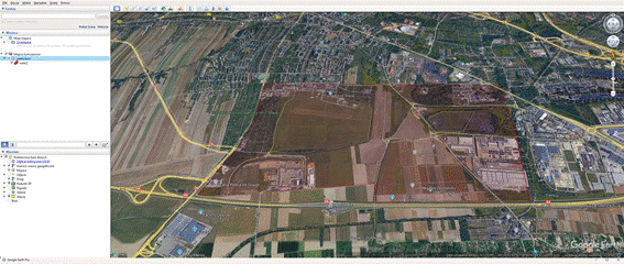
Fig. 1.
Photogrammetric flight area over Gliwice-Trynek
aerodrome
In
the next phase of the study, a detailed photogrammetric flight plan over the
Gliwice-Trynek aerodrome area was developed. Mission
preparation and execution were carried out using the dedicated DJI Pilot 2
software installed on the ground control unit of the DJI Mavic 3 Enterprise
UAV. The choice of the DJI Mavic 3 Enterprise was dictated by its superior
technical parameters, optimal mobility, and compact size (weighing only 915 g),
which are crucial operational advantages in the highly dynamic and restricted
environment of an active aerodrome. While higher-end alternatives like the DJI
Matrice 300 RTK were considered, the Mavic 3 Enterprise was ultimately selected
due to its immediate operational availability, circumventing the lengthy
administrative procedures associated with institutional equipment and allowing
for flexible scheduling aligned with the aerodrome's operational windows.
Theoretically, compared to standard consumer drones, the Mavic 3 Enterprise
offers
a significant advantage through its 4/3 CMOS sensor and mechanical shutter,
which effectively eliminate the rolling shutter effect – a critical requirement
for high-resolution, distortion-free photogrammetric imaging and flight
stability. The DJI Pilot 2 software was selected to ensure seamless, native
compatibility with the hardware, guaranteeing reliable execution of the
programmed flight grid without the integration issues occasionally encountered
with third-party applications.
The
survey was performed using the default settings recommended by DJI Pilot 2,
which the application automatically tailored to the specifics of the planned
mission, thereby guaranteeing adherence to the predetermined accuracy
thresholds and spatial-imaging parameters (Fig. 2). The photogrammetric flight
covered an area of 6.24 km² and was conducted at an altitude of 120 m AGL
(Above Ground Level), achieving an optimal balance between terrain-detail
fidelity and operational efficiency. The applied flight altitude of 120 m was
strictly dictated by the legal constraints of the European Union Aviation
Safety Agency (EASA) and national regulations, which restrict UAV operations in
this category to a maximum of 120 m AGL. Operationally, this altitude provided
the optimal compromise, allowing for the efficient coverage of a large area
within a reasonable timeframe while maintaining a high Ground Sample Distance
(GSD) sufficient for accurate 3D modeling. Regarding
the built-in wide-angle camera (84° FOV), such lenses inherently introduce
radial and tangential distortions that could theoretically vary with altitude.
Since empirical testing at different heights was precluded by the
aforementioned legal altitude limit, these optical distortions were
successfully mitigated during the post-processing phase. The photogrammetric
software utilizes an auto-calibration algorithm during the image alignment
process (based on Brown's distortion model) to mathematically calculate and
compensate for lens distortions across the dataset, ensuring high geometric
accuracy regardless of the wide field of view.
The
total duration of the flight campaign, including necessary technical breaks for
UAV battery replacements and adjustments to comply with the current operational
requirements and safety procedures in force at EPGL, amounted to approximately
four hours. Throughout the operation, complete oversight of the mission and
continuous assessment of air-traffic conditions in the vicinity of the
aerodrome were maintained, which was essential given the dynamic nature of the
operating environment and the possibility of unforeseen changes in airspace
organization.
|
|
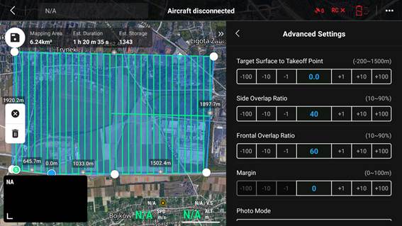
Fig. 2.
Photogrammetric flight plan over Gliwice-Trynek
aerodrome
The
acquisition of photogrammetric data was carried out using the onboard
wide-angle camera integrated into the DJI Mavic 3 Enterprise UAV (Fig. 3).
During the flight campaign, a total of 1 398 high-resolution digital
photographs were captured. The cumulative size of the collected imagery
exceeded 10 GB.
In
the next phase of the study, all photogrammetric data acquired during the UAV
flight campaign were subjected to processing in Agisoft
Metashape. Upon importing the entire set of
high-resolution images into the software environment, a thorough initial
quality assessment was conducted, during which any photographs exhibiting
suboptimal exposure levels or insufficient resolution – factors that could
potentially compromise the integrity of the final 3D model – were
systematically excluded.
|
|
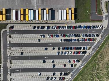
Fig. 3. Sample
photograph captured during the photogrammetric flight
The
first major operation within the reconstruction workflow involved the
image-alignment procedure. This step successfully identified and matched 1 449
664 tie points across overlapping photographs, resulting in the creation of the
so-called sparse point cloud. This preliminary point cloud serves as the
foundational approximation of the spatial structure of the surveyed area.
Subsequently,
the workflow progressed to the generation of a dense point cloud. Advanced
photogrammetric algorithms were applied, taking into account both the internal
(intrinsic) and external (extrinsic) orientation parameters of the camera. By
performing precise pixel-level matching across the aligned images, these
algorithms produced a highly detailed spatial representation of all visible
features. The dense-cloud generation yielded a total of 424 348 298 points,
thereby enabling an exceptionally accurate reconstruction of the terrain’s
topographic variations.
The
conversion of the dense point cloud into a fully triangulated three-dimensional
mesh entailed several sequential operations. First, all point clouds were
co-registered and optimally aligned. Next, surface-reconstruction algorithms
were applied to interpolate between points and construct the geometric
framework of both natural landforms and man-made infrastructure. The resulting
mesh comprises 37 million polygons, which provides a rich geometric detail
suitable for both visual examination and quantitative spatial analysis of
Gliwice-Trynek aerodrome and its immediate
surroundings.
An
evaluation of the stitching quality of the 1 398 separate images confirmed a
highly successful reconstruction of the expansive aerodrome surface. The
application of the 'Aggressive' depth filtering parameter effectively
eliminated most outliers and noise, resulting in a cohesive and continuous mesh
for the vast majority of the mapped area without significant artifacts. A
notable exception, however, was the water reservoir located east of the
aerodrome. Water surfaces inherently lack static tie points due to their
homogeneity, reflectivity, and continuous motion. Consequently, while the
visual 3D model (mesh texture) exhibited only minor visual artifacts in this
area, the Digital Elevation Model (DEM) encountered processing difficulties,
resulting in local topological inaccuracies over the water's surface. Despite
this isolated issue, the overall geometric fidelity of the terrain and critical
aerodrome infrastructure remained highly accurate and fully suitable for
subsequent spatial hazard analysis.
Finally,
a 2.5D Digital Elevation Model was generated from the dense point cloud. This
step involved rasterizing the three-dimensional information onto a regular
grid, assigning to each grid cell a specific elevation value that accurately
reflects the underlying surface morphology. The completed DEM met all
predefined quality and accuracy criteria, thus forming a robust basis for
subsequent analyses of how local terrain characteristics may influence the
safety and performance of flight operations at the study site (Fig. 4).
|
|
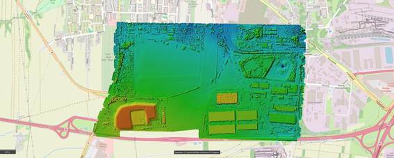
Fig. 4.
Digital Elevation Model of Gliwice-Trynek aerodrome
4. RESULTS
The developed three-dimensional model of Gliwice-Trynek
aerodrome and its immediate surroundings (Fig. 5) constitutes a substantial
source of information on terrain obstacles and infrastructure components, all
of which directly affect the safety and systematic organization of flight
operations conducted at this facility.
|
|
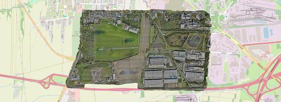
Fig.
5. 3D model of Gliwice-Trynek aerodrome and its
approach areas
The analysis of the model revealed that the aerodrome
terrain is characterized by a relatively flat relief, lacking any significant
natural elevations or ground‐based obstacles in the immediate vicinity of
the aerodrome’s operational infrastructure. This morphological uniformity has
important operational implications, as it enables the establishment of stable
and predictable approach and departure paths, as well as the correct
delineation of the aerodrome traffic circuit.
Within the surveyed area, several notable anthropogenic
features were identified – residential and industrial buildings, warehouse
facilities, forested zones, a waste‐disposal site, and a water reservoir
– all of which exert a direct or indirect influence on the planning and
execution of flight operations. In the immediate surroundings of the aerodrome,
structures such as buildings and masts reach heights ranging from 12.5 m to
over 20 m above ground level, necessitating their inclusion in the design of
approach, take‐off, and missed‐approach procedures. In particular,
these obstacles affect minimum overflight altitudes and the permissible
flight‐path parameters during each phase of flight operations.
Forested areas located in close proximity to the runway
complex represent an additional factor impacting flight activity. Their
presence along the approach axis or runway alignment can induce localized
meteorological variations – such as modifications in wind patterns, air
temperature stratification, and humidity levels – which bear directly on the
safety of take‐off and landing operations, especially for glider and
helicopter flights conducted at lower altitudes.
The waste‐disposal site, situated in the southern
sector of the study area, constitutes a terrain obstacle of variable height.
Its exact position and elevation profile must be mandatorily accounted for when
planning low‐altitude flight trajectories and in the formulation of
emergency procedures.
Another element affecting local operating conditions is
the water reservoir located to the east of the aerodrome zone. This body of
water may give rise to micro‐meteorological phenomena – such as elevated
air humidity and the formation of radiation fog – which can substantially
reduce visibility and atmospheric stability, particularly during morning and
evening hours.
Accounting for all the aforementioned environmental and
infrastructural elements is essential to the correct planning and safe
execution of flight operations in the Gliwice-Trynek aerodrome area. An
integrated spatial analysis – based on data derived from the
three‐dimensional model – enables precise delineation of
height‐restriction zones and the adjustment of operational procedures to
current terrain and environmental conditions [10].
5. DISCUSSION
Gliwice-Trynek aerodrome is situated within an area
characterized by favorable terrain morphology, alongside environmental and
anthropogenic features that may pose potential hazards to flight operations.
Both the underlying terrain relief and the distribution of natural and man-made
obstacles in the immediate vicinity of the aerodrome infrastructure are of
critical importance for operational safety.
The analysis demonstrated that the aerodrome occupies
predominantly flat terrain, which facilitates aerial operations by eliminating
risks associated with elevation differentials. However, residential and
industrial buildings, as well as technical-infrastructure elements, are located
in close proximity to the runways (Fig. 6). Their elevation characteristics and
spatial arrangement relative to the take-off and approach paths must therefore
be duly considered within flight-operation procedures.
The spatial arrangement and distribution of built
structures in the immediate proximity of critical operational zones – including
runway strips, aircraft aprons, taxiways, and final approach corridors –
necessitates a comprehensive spatial analysis and meticulous planning of all
associated flight procedures. These edifices, by virtue of their vertical
dimensions and precise siting, can restrict the usable volume of airspace,
influence the establishment of minimum overflight altitudes, and alter
available aerial corridors, thereby constraining the maneuverability of
aircraft in the aerodrome’s vicinity.
|
|
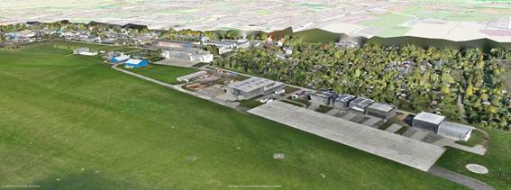
Fig.
6. Three-dimensional model of buildings on the Gliwice-Trynek
aerodrome grounds
Moreover, the presence of tall buildings and other
constructions generates complex aerodynamic phenomena, such as localized
vortices and irregular wind currents, which exert a direct impact on flight
operations during both the approach and landing phases as well as during
initial climb. Such phenomena have the potential to compromise the stability of
the flight path and demand heightened corrective inputs from flight crews when
navigating these critical zones.
An additional operational consideration is the reduction
of visual cues and overall visibility caused by the proximity of built
structures. These sight-line obstructions affect not only airborne crews but
also ground personnel – particularly under conditions of poor meteorological
visibility, including fog, precipitation, or the onset of dusk.
Furthermore, groups of trees and contiguous forest
complexes – especially those situated along the approach axes to runways 08 and
10 (Fig. 7) – pose further limitations. These natural obstacles, owing to their
height and alignment relative to the runway centerlines, can impact both
climb-out and approach trajectories, while also influencing local
micro-meteorological conditions. In particular, they may increase the incidence
of mechanical turbulence and lead to variable wind directions within the near-ground
layer, thereby presenting an additional factor to be mitigated during
flight-operation planning.
|
|
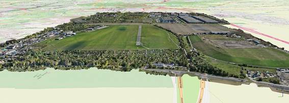
Fig.
7. Groups of trees on the approach to runways 08 and 10
Natural forest stands, as significant terrain obstacles,
substantially restrict the available airspace immediately surrounding the
aerodrome, thereby compelling flight crews to meticulously adjust both take-off
and approach procedures. In particular, departures from runways 08 and 10 are
affected by the presence of tall trees located just before the runway
thresholds; aircraft must execute a steeper climb gradient to ensure sufficient
obstacle clearance. This requirement imposes a considerable challenge for
platforms with limited climb performance, as the greater the height of
vegetation directly aligned with the runway centerline, the more constrained
becomes the minimum safe overflight altitude, and the less latitude there is in
planning both arrival and departure flight paths.
Similarly, during landing operations, these trees within
the glide path force pilots to maintain a higher threshold-crossing height.
This adjustment effectively reduces the available landing distance, thereby
increasing the probability of runway overruns – particularly under adverse
meteorological conditions such as heavy precipitation, gusting winds, or low
visibility. Additionally, forest stands generate localized vortices and
mechanical turbulence, most pronounced in strong wind scenarios, which can induce
unexpected deviations in the flight path during the critical final approach
phase. These aerodynamic disturbances are inherently difficult to forecast
accurately, and their intensity depends closely on prevailing wind direction
and speed.
Moreover, the presence of extensive wooded areas in
proximity to the aerodrome attracts bird populations, which in turn present a
serious hazard to flight safety. Bird strikes occurring at low altitudes during
take-off and landing phases significantly elevate the risk of ingestion events
that may damage engines or impair other vital onboard systems. To mitigate
these avian hazards, it is recommended that aerodrome management implement
systematic vegetation control measures – such as strategic tree trimming – and
deploy dedicated bird-monitoring and deterrence systems throughout the
aerodrome perimeter [6].
Finally, particular attention must be paid to the
waste-disposal site and adjacent warehouse complexes located to the south of
Gliwice-Trynek aerodrome. These man-made structures, by virtue of their
considerable height and specific spatial arrangement, alter local aerodynamic
conditions by inducing a Venturi-type effect. The constriction of airflow
between closely spaced obstacles causes an increase in wind velocity alongside
a corresponding drop in dynamic pressure within the resulting airflow corridor.
Such localized wind acceleration can destabilize flight operations during
periods of southerly winds (Fig. 8), with direct implications for both
climb-out and approach trajectories. Consequently, these effects necessitate
heightened procedural caution in flight-path planning and demand increased
situational awareness and vigilance from flight crews when conducting
operations in this sector.
The elevation model developed for the Gliwice-Trynek
aerodrome (Fig. 4) clearly highlights significant elevation differences between
the waste-disposal site and warehouse complexes – depicted in orange – and the
level of the surrounding terrain, shown in shades of green and blue. Field
measurements revealed that the height of these man-made structures is
approximately 25 m above ground level.
The observed Venturi effect, manifesting as a localized
acceleration of wind between tall obstacles, directly impacts flight operations
– especially during the critical phases of take-off and landing. Elevated
wind-stream velocities in the near-ground layer can destabilize aircraft flight
paths precisely when aerodynamic susceptibility is greatest. Sudden wind-speed
increases due to the Venturi effect may force flight crews to make rapid,
dynamic corrections to their course and approach parameters. In practice, this
can lead to runway overshoots beyond the intended touchdown zone, thereby
reducing the effective runway distance available for aircraft deceleration and
safe rollout [4].
|
|
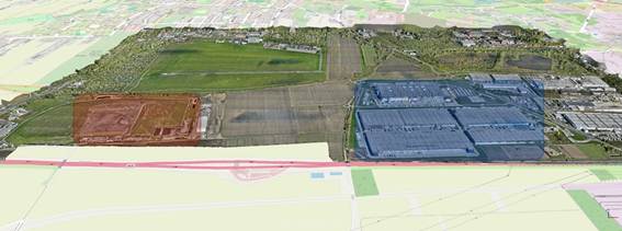
Fig.
8. 3D model of Gliwice-Trynek aerodrome with marked
waste-disposal site (in red) and warehouses (in blue)
At Gliwice-Trynek, where these obstacles lie to the south
of the primary runway, wind acceleration in this operational sector poses a
heightened hazard for departing aircraft. Airframes with limited tolerance for
abrupt wind-speed changes may experience difficulty maintaining stable climb
performance immediately after lift-off. An unexpected surge in airflow during
this phase can lead to loss of control, requiring crews to execute swift and
precise flight-parameter adjustments to preserve safety.
It is important to note that the Venturi effect is not
exclusively associated with southerly winds. Depending on prevailing wind
direction and intensity, similar accelerative phenomena can occur in different
areas of the aerodrome’s airspace; however, their magnitude and spatial
distribution will vary accordingly. Narrow passages between large structures
act as aerodynamic channels, intensifying local airflow and obliging flight
crews and air-traffic controllers to continuously adapt flight parameters and control
procedures – thereby imposing an additional cognitive and operational workload
on all personnel.
Thus, the combination of the waste-disposal site,
warehouse complexes, and the resultant Venturi effect creates unique
aerodynamic conditions within the Gliwice-Trynek aerodrome operating area that
influence every phase of flight operations. Increased wind speeds, associated
turbulence, and rapidly changing aerodynamic conditions demand heightened
vigilance and exacting procedural compliance from both flight crews and ground
personnel to ensure the highest possible level of safety.
An additional factor shaping local meteorological
conditions is the water reservoir situated to the east of Gliwice-Trynek
aerodrome (Fig. 9). Its presence affects atmospheric parameters around the
aerodrome, with direct implications for the safety and efficiency of ongoing
flight operations.
The thermal and hygrometric properties of water
reservoirs give rise to distinct and often complex meteorological phenomena
that can markedly affect flight operations – particularly during take-off,
landing, and low-altitude maneuvering phases. A primary hazard associated with
the proximity of such bodies of water to aerodromes is the increased likelihood
of radiation fog formation during clear, cool nights and advection fog under
warm, moist airflow – conditions most prevalent in the early morning and late
evening hours. These fog events frequently result in severe visibility
reductions within the designated approach corridors, thereby complicating the
precise execution of approach and landing procedures and substantially
elevating the probability of an improper runway touchdown or, alternatively,
the necessity to execute a missed-approach and go-around maneuver.
|
|
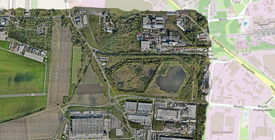
Fig.
9. Water reservoir in the vicinity of Gliwice-Trynek
aerodrome
Moreover, temperature contrasts between the cooler water
surface and the warmer adjacent land generate localized shifts in both wind
direction and speed. Such micro-meteorological effects manifest as turbulent
zones and small-scale vertical air currents – both updrafts and downdrafts –
that can severely destabilize an aircraft precisely as it enters the most
critical stages of its flight profile. Flight crews must therefore remain on
high alert and prepared to implement immediate trajectory corrections in order
to maintain a stabilized glide path and ensure adherence to the flight plan.
Additionally, elevated levels of water vapor emanating from the reservoir
foster the development of low-level stratiform clouds, contributing further to
changes in moisture content and directly influencing aerodynamic efficiency –
particularly affecting wing lift and drag characteristics, thereby altering
climb rates, descent paths, and overall performance profiles.
Another significant operational threat inherent to nearby
water bodies is solar glare – intense sunlight reflecting off the water’s
surface directly into the eyes of flight crews. This glare is especially acute
when the sun sits low on the horizon, during both sunrise and sunset periods.
Such reflections can momentarily impair external visual references as well as
the readability of cockpit instruments, making it difficult for pilots to
accurately gauge distances to the runway or determine their height above
ground. In extreme cases, glare-induced visual impairment may precipitate
temporary disorientation or erroneous assessments of critical flight
parameters, thus necessitating an immediate go-around or missed-approach
decision. This seasonal phenomenon intensifies during spring and summer months,
when daylight hours are extended and the incidence of strong solar radiation is
at its peak.
Surface heterogeneity at and around Gliwice-Trynek
aerodrome – comprising both hard pavements such as asphalt and concrete
alongside natural grass areas – also exerts a profound influence on the local
microclimate and thermal regime. Differences in specific heat capacity and
thermal conductivity between these materials lead to uneven surface heating
throughout the day. Pavement surfaces absorb and re-radiate heat more rapidly
and to a greater extent than grass fields, creating thermal plumes, localized turbulence
zones, and micro-eddy formations near runway thresholds. These thermal currents
may intermittently disrupt both approach trajectories during landing phases and
initial climb gradients during take-off, thereby requiring pilots to execute
dynamic, in-flight adjustments to their flight-control inputs and to maintain a
continuous awareness of changing aerodynamic conditions.
Uneven ground heating can further precipitate the
formation of thermal inversion layers, which disrupt the normal vertical
airflow above the aerodrome. On warm, sunny days, asphalt and concrete surfaces
emit considerable amounts of stored heat into the immediate atmosphere,
generating localized low-pressure pockets that draw in cooler air from the
surrounding natural terrains. This inflow produces irregular horizontal and
vertical air currents, enhanced turbulence, and mixing layers in close
proximity to the runway environment – collectively elevating the operational
risks associated with both departure and arrival phases, where precise attitude
and speed control are paramount.
Importantly, these thermal effects persist well into
nighttime hours, as artificial surfaces gradually release the heat they have
accumulated during daylight, maintaining local temperatures above those of the
adjacent fields, forests, and meadows. These nocturnal thermal emissions
influence air-density gradients, thereby modifying lift coefficients, affecting
engine performance, and altering aircraft handling characteristics at low
altitudes.
The juxtaposition of industrial hard-scapes, urbanized
zones, and natural landscapes – such as forests, meadows, and water bodies –
further intensifies micro-meteorological phenomena around the Gliwice-Trynek
aerodrome. Differentially heated surfaces create alternating pressure zones,
rising thermal columns, and updraft corridors, each contributing to a highly
dynamic airflow environment. Flight crews must therefore continuously monitor
ambient conditions via onboard instruments and visual cues, executing real-time
flight-parameter adjustments to anticipate and counteract sudden encounters
with updrafts or downdrafts. Maintaining aerodynamic stability under these
variable conditions demands both precise stick-and-throttle coordination and
heightened situational awareness.
Overall, the variable thermal conditions and attendant
localized wind-shear events – characterized by abrupt shifts in wind direction,
speed, and density – constitute additional hazards during the most critical
phases of flight. These phenomena can induce momentary lift loss, unintended
roll or pitch excursions, or unexpected deviations from the planned flight
path, thereby requiring prompt and decisive corrective action by flight crews.
Ensuring the highest levels of safety for all operations within the Gliwice-Trynek
aerodrome vicinity thus depends on rigorous procedural compliance, continuous
meteorological monitoring, and the capacity of crews and ground personnel to
adapt swiftly to changing aerodynamic and environmental circumstances.
6. CONCLUSION
The development of a three-dimensional spatial model of Gliwice-Trynek aerodrome proved to be a highly effective tool for
assessing the influence of terrain morphology and existing infrastructure on
the safety and efficiency of flight operations. The results of the conducted
analyses demonstrated that the use of low-altitude photogrammetry with unmanned
aerial vehicles (UAVs) constitutes one of the most precise and efficient
methods for acquiring spatial data. This approach enables faithful reproduction
of real-world topography in a three-dimensional environment, as well as the
identification of landscape features and infrastructural elements that may pose
hazards to flight safety – particularly in areas characterized by complex
terrain relief.
For the study area in question, it was shown that the presence of
buildings and natural land-formations within specific sectors immediately
adjacent to the aerodrome affects the safety of ongoing operations, especially
during approach and landing phases as well as take-off procedures. These
findings underline the necessity for systematic monitoring and periodic
updating of spatial models covering areas contiguous to aerodrome
infrastructure, with the aim of ensuring their conformity to the current state
of the operational environment.
The analysis also highlighted significant benefits arising from the
application of UAVs in aerodrome photogrammetric surveying. The integration of
this technology with aerospace engineering systems and airspace-management
platforms points the way toward future standards in the oversight of aerodrome
operational environments. The photogrammetric data collected – when integrated
into digital airspace-management systems – facilitate the prediction of
potential hazards and the identification of aerial obstacles, thereby
supporting the development of autonomous UAV systems and enhancing overall
operational safety in the long term.
Moreover, precise and up-to-date photogrammetric representations make it
possible to forecast the impact of surrounding infrastructure and topographic
conditions on approach paths and departure trajectories. This capability is
especially critical at aerodromes with intricate spatial configurations. The
results obtained confirm that the rapid advancement of drone technologies
enables the generation of high-resolution spatial models, which, in turn,
assist aerodrome managers in continuously monitoring zones adjacent to
operational areas.
In conclusion, the findings of this study affirm that the implementation
of UAV-based monitoring of aerodrome operational environments represents a
significant frontier in modern aerospace engineering. They also underscore the
considerable potential of this technology to streamline spatial-planning
processes and improve airspace management around aerodrome perimeters.
References
1.
Brassel
Hannes, Alexander Zouhar, Hartmut Fricke. 2020. „3D Modeling of the aerodrome
environment for fast and accurate LiDAR semantic segmentation of apron
operations”. In: AIAA/IEEE 39th Digital Avionics Systems Conference (DASC): 1-10. San Antonio, USA. 11-15 October 2020. San
Antonio, USA. DOI: 10.1109/DASC50938.2020.9256495.
2.
Cisło-Lesicka
Urszula. 2010. „Generation of 3D buildings for three-dimensiona
lmultiresolution topographic database”. Archiwum
Fotogrametrii, Kartografii i Teledetekcji 21: 63-73. ISBN: 978-83-61576-13-6.
3.
Jarząbek-Rychard
Małgorzata. 2015. „3D building modeling based on laser scanning data”. PhD
thesis, Wroclaw, Poland: Wrocław University of Environmental and Life Sciences.
4.
Leung
Dennis Y.C., W.Y. Lo, W.Y. Chow, P.W. Chan. 2012. „Effect of terrain and
building structures on the airflow in an aerodrome”. Journal of Z hejiang University Science A 13(6): 461-468. DOI:
10.1631/jzus.A1100293.
5.
Michałowska Krystyna
(ed.). 2015. Modelowanie i wizualizacja
danych 3D na podstawie pomiarów fotogrametrycznych i skaningu laserowego.
Rzeszów: Wyższa Szkoła Inżynieryjno-Ekonomiczna z siedzibą w Rzeszowie. [In Polish: 3D data modeling and visualization
based on photogrammetric measurements and laser scanning.
Rzeszów: University of Engineering and Economics in
Rzeszów]. ISBN: 978-83-60507-29-2.
6.
Mitsevich
Liudmila, Natalia Zhukovskaya. 2021. „3D modeling and GIS analysis for
aerodrome forest obstacle monitoring”. The
International Archives of the Photogrammetry, Remote Sensing and Spatial
Information Sciences XLIII-B2-2021: 753-757. DOI: 10.5194/isprs-archives-XLIII-B2-2021-753-2021.
7.
Oszczak Bartłomiej,
Dariusz Tanajewski, Adam Harmaciński,
Mateusz Klimczuk. 2011. „3D modeling of buildings at the aerodrome
Dajtki-Olsztyn in applications AutoCAD Civil 3D and Google SketchUp”. Annals of Geomatics 4(48): 129-137. ISSN: 1731-5522.
8.
Quan
Xiuhao, Reiner Doluschitz. 2021. „Unmanned
aerial vehicle (UAV) technical applications, standard workflow, and future
developments in maize production – water stress detection, weed mapping,
nutritional status monitoring and yield prediction”. Landtechnik 76(1): 36-51. DOI:10.15150/lt.2021.3263.
9.
Rábago
Jordi, May Portuguez-Castro. 2023. „Use of drone photogrammetry as an
innovative, competency-based architecture teaching process special issue”. Drones 7(7): 1-19. DOI:
10.3390/drones7030187.
10.
Zawisza
Tomasz. 2023. „Traffic safety management on the apron using a heuristic
algorithm”. PhD thesis, Warsaw, Poland: Warsaw University of Technology.
11.
Zhang
Ziya,Weijun Pan, Junjie Zhou, Qiyang Zhang. 2021. „Research on rapid 3D
modeling of aerodrome navigation facilities based on oblique photography
technology”. IOP Conf. Series: Earth and
Environmental Science 693: 1-6. DOI:10.1088/1755-1315/693/1/012095.
Received 04.12.2025; accepted in
revised form 30.04.2026

Scientific
Journal of Silesian University of Technology. Series Transport is licensed
under a Creative Commons Attribution 4.0 International License