Article
citation information:
Maciuk, K., Rudyk, Y. Usage of the global navigation
satellite systems in safety and protection issues. Scientific Journal of Silesian University of Technology. Series
Transport. 2020, 109, 93-102.
ISSN: 0209-3324. DOI: https://doi.org/10.20858/sjsutst.2020.109.9.
Kamil MACIUK[1], Yuriy
RUDYK[2]
USAGE
OF THE GLOBAL NAVIGATION SATELLITE SYSTEMS IN SAFETY AND PROTECTION ISSUES
Summary. Currently, global
navigation satellite systems (GNSS) play a key role in the broad field of
security and human life. In principle, almost every area of human activity (for
example, mining, energy or construction) systems related to saving human life
are introduced. Generally, satellite navigation is an indispensable element of
this type of systems. In this paper, authors present basic principles of the
GNSS operation and the current state of knowledge about usage of the global
navigation satellite systems in the area of safety, protection and rescue
issues.
Keywords: GNSS, GPS, protection, safety, satellite
systems
1. INTRODUCTION
One of the ways to achieve safety in
the broadest sense is to guarantee a certain level of emergency detection,
assistance, and rescue. There are many definitions of SAR (Search and Rescue)
depending on the country, approach and agency involved. The Canadian Forces
describe it as ‘Search and Rescue
comprises of the search for, and provision of aid to persons, ships or other
vehicles which are, or are feared to be, in distress or imminent danger’ (http://www.towarf.com/sarsystem.html), while the United States Coast Guard
‘The use of available resources to
assist persons or property in potential or actual distress’ (https://enacademic.com/dic.nsf/enwiki/116405), they are also other definitions. All of
them connect the necessity of providing help to people who are in actual or
potential danger or distress. Currently, an inseparable element of SAR is
Global Navigation Satellite Systems (GNSS), without which SAR would be
significantly impeded, and slowed down. GNSS has been used in navigation and
positioning since the 80s. Among the first of them: GPS (Global Positioning
System) and GLONASS (Global Navigation Satellite System); there are other providers:
Beidou, Galileo and QZSS (Quasi-Zenith Satellite System). Our focus is on the
use of GNSS in emergency and security issues. The first section (Introduction)
contains a summary of the literature research on the use of GNSS in SAR.
Second, the basic of GNSS positioning describes the principles of GNSS
positioning. Third and fourth describe the current state of knowledge regarding
search and rescue applications, respectively.
GIS (Geographic Information System) is
among the other sources of gathering positions from GNSS. Emergency command and
rescue strongly relies on spatial information: first, are positioning of the
emergency events, the search of surroundings environments or GPS tracking,
these GIS applications in emergency rescue are described by (Yao et
al., 2011). Nowadays,
a lost phone is a serious problem due to its use as a personal ID or as a
credit card. The loss occurs because of two major reasons: user’s own
fault (destruction or loss) or due to theft (Kristian
et al., 2012). Appropriate
applications allow determining the phone’s last known position through
the use of a GNSS receiver. Mobile phones are also used in 112 emergency calls
and determining the receiver location (Ptolemus,
2014). On the other hand, GPS might be used
for national security improvement (Akinode,
2011). We describe such applications as
a tracking system for monitoring employees who travel long distances. It
allows to improve company productivity, ensure drivers do not exceed the speed
limit and meet their delivery schedule. Another application in this field is
parole by using a small tamper-proof receiver worn as a bracelet or anklet. We
describe the use of GPS positioning to track suspected terrorists, demented
persons or stolen cars. The use of GPS and the GIS in road accident mapping and
emergency response management have been the subject of many studies (Muthoni
Njeru and Imwati, 2016). We propose a new system for car
accident reporting mechanisms to get more accurate geographical localisations
as the data is not being used by police departments. Wadhe et al. 2016 proposed
the use of the application for tracking ambulance. We described a model to track the
nearest free ambulance using a global positioning system and bring it to the
person in distress. A similar idea was conducted by Wadhe
et al. (2016), proposing
the algorithms for ambulance tracking by the hospital management using GPS.
Furthermore, we propose the use of GSM-trackers on fire service units in action
along with database support on duplex transmission via the GIS portal. The GSM
technology is used to transmit the signal to the off-site monitoring centre,
while the GPS technology is used to determine the precise location of the
tracking device. We propose developing a system for women protection by using
GPS and GSM (Global System for Mobile Communications) as suggested (Devi
and Nayak, 2017). Location based services (LBS) using
mobile phones are described (Wankhede,
2018), who
proposed an application that would provide information regarding services such
as the nearest hospital, police station or a blood bank. Similar to the above,
GPS/GNSS applications in an emergency and security issues were also submitted
by other authors (Akinode,
2011; Anon, 1994; Devi and Nayak, 2017; Lee et al., 2019).
2. BASIC OF GNSS POSITIONING
Each GNSS system consists of three
parts (segments): space, ground and user segment. Space segment are satellites
on the orbit, control segment is a ground-based network of master control, data
upload and monitor stations. The user segment is the equipment that processes
the signals received by the GNSS satellites (Akinode,
2011). GNSS positioning is generally based
on the precise time measurement on the satellite-receiver distance. Fig. 1
presents a general schema of steps involved in GNSS positioning. GNSS
satellites positions are assumed to be known and are transmitted via broadcast
message together with satellite clock correction. Control segments, when
necessary, adjust satellites’ ephemeris and time. GNSS signal passes
through the atmosphere to the user equipment.
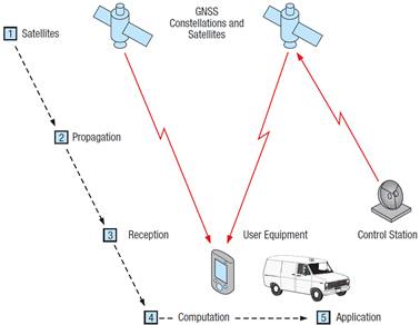
Fig. 1. GNSS principle of the operation (Charles, 2010)
Single receivers position is
determined on the basis of trilateration based on the knowledge of at least 4
satellites’ positions and each distances receiver-satellite (Ogaja,
2011). The unknowns are 3 components
of receiver position and a receiver clock correction (Fig. 2).
Each GNSS satellite transmits both
code and phase signals on two (older blocks) or more frequencies together with
navigational data containing the satellite’s position, time, health and
other information. Phase observations are used for more demanding and precise
applications as geodesy or engineering. In case of emergency and security
issues, code-only receivers are used, the same as in touristic or mobile phone
receivers. It provides a couple of metres accuracy level which is sufficient
for this kind of applications.
Determining the user’s position
(![]() ,
, ![]() ,
, ![]() ) and the receiver clock offset (
) and the receiver clock offset (![]() ) requires at least four visible
satellites (Montenbruck
et al., 2018). Based on
the pseudoranges
) requires at least four visible
satellites (Montenbruck
et al., 2018). Based on
the pseudoranges ![]() recorded by the receiver, a set of
equations is determined as:
recorded by the receiver, a set of
equations is determined as:
|
|
|
(1) |
where ![]() are pseudorange of ith satellites (i = 1, 2, …, n),
are pseudorange of ith satellites (i = 1, 2, …, n), ![]() ,
, ![]() ,
, ![]() are receiver’s coordinates which
are unknown,
are receiver’s coordinates which
are unknown, ![]() ,
, ![]() ,
, ![]() are ith
satellite coordinates, ith satellite,
are ith
satellite coordinates, ith satellite,
![]() is a speed of light in vacuum and
is a speed of light in vacuum and ![]() is a receiver clock error. Based on the
least squares estimation technique, in a matrix form:
is a receiver clock error. Based on the
least squares estimation technique, in a matrix form:
|
|
|
(2) |
where ![]() is a vector of observations,
is a vector of observations, ![]() is a matrix of linear functions of
unknowns and
is a matrix of linear functions of
unknowns and ![]() is a vector of unknowns(Ogaja,
2011). The least square solution of (2)
leads to:
is a vector of unknowns(Ogaja,
2011). The least square solution of (2)
leads to:
|
|
|
(3) |
where ![]() is the weight matrix, assumption of the
weight matrix equal
is the weight matrix, assumption of the
weight matrix equal ![]() leads to Equation 3 without matrix
leads to Equation 3 without matrix ![]() . Pseudorange measurements are also
appropriately modelled based on the receiver class and the accuracy assumed to
receive. Currently, the number of GNSS applications is very wide, among
everyday life, from engineering to scientific (Konopka
et al., 2013; Skorupa, 2019).
. Pseudorange measurements are also
appropriately modelled based on the receiver class and the accuracy assumed to
receive. Currently, the number of GNSS applications is very wide, among
everyday life, from engineering to scientific (Konopka
et al., 2013; Skorupa, 2019).
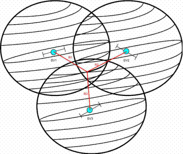
Fig. 2. Trilateration rule using signals
from three satellites (Assir,
2011)
3. SEARCH APPLICATIONS
Search and Rescue (SAR) as a part of
emergency operations involve locating and helping people in distress. The
Galileo Initial Services was the first GNSS constellation offering global SAR
capability (Fontanier
et al., 2019; Ilčev, 2018). The SAR/Galileo service is
Europe’s contribution to the upgrade of COSPAS-SARSAT, an international
satellite-based SAR distress alert detection and information distribution
system (Barnes
and Clapp, 1995; Lee et al., 2019). Established
in 1979, it is used to detect and locate emergency beacons activated by
aircraft, ships and individuals. It provides accurate, reliable and timely
alert and location data from distress beacons in the 406-406.1 MHz band and
broadcast this information to dedicated ground stations (MEOLUTs) in the L-band
at 1544.1 MHz (Wang
and Wang, 2019). Currently, over 40 countries and
organisations participate in the operation and management of the COSPAS-SARSAT
system, which also cooperates with the International Civil Aviation
Organization (ICAO), the International Maritime Organization (IMO) and the
International Telecommunication Union (ITU) (Barnes
and Clapp, 1995). The time to detect a person at sea
or in the mountains ranges from one hour to just 10 minutes after the distress
beacon is activated; localisation of the distress beacon from 10 km to less
than 5 km; location accuracy after 1 transmitted burst within 5 km >70%, -
12 bursts and 10 min - >95% (https://www.gsa.europa.eu/european-gnss/galileo/services/search-and-rescue-sargalileo-service).
State-of-the-art software, database
access, and instant cross-communication capability make it possible to collect
publicly available electronic maps online with any geospatial information
updated in real-time. This algorithm was effective in preventing and
eliminating the consequences of emergencies and humanitarian disasters, which
led to the emergence and rapid increase of the crisis mapping segment. As the
core idea of crisis web mapping is the mass participation of users in the
collection of necessary data (crowdsourcing), the “locomotive” of
its development at the current stage is non-state, usually volunteer, online
communities and organisations. Similarly, the use of the innovative potential
of crisis cartography by official bodies; international organisations,
governments, and rescue bodies, is becoming quite extensive. To increase the informativeness
of electronic project maps, crowdsourcing data is increasingly being
complemented by high-tech professional information (for example, satellite
data). The central principle of the architecture of this system is dynamic,
synchronised in time and space, complex, multi-level visualisation of the
entire array of data obtained from different sources (Lu et
al., 2015), on a
platform of special mapping web resources. Presently, the global system
(infrastructure) of mass web mapping is in its infancy and has a decentralised,
multi-layered architecture that combines both global Google Maps (https://www.google.com/maps), Open
Street Map (https://www.openstreetmap.org),
Bing Maps (https://www.bing.com/maps)
and local Sudan Satellite Sentinel Project (http://www.satsentinel.org/), CERA (http://cera.govt.nz/), Yandex Maps (https://yandex.com/maps/)
and wide-ranging and crisis-driven services like Development Seed (https://developmentseed.org) or Tomnod (http://www.tomnod.com) that can be proprietary and non-profit, research
centres, for example, Crisis Mapping and Early Warning Program within the
Harvard Humanitarian Initiative (https://hhi.harvard.edu/resources/crisis-mapping-and-early-warning), are
diverse online communities, blogs, forums Green Map System (https://www.greenmap.org), iRevolution
(https://www.irevolution.com), and more. Meanwhile, network organisations that play
the role of global focal points and discussion venues have already emerged, in
the crisis web mapping segment, for example, the International Network of
Crisis Mappers (https://crisismapping.ning.com/), which at present,
brings together more than 1,700 organisations and about 2,000 web mappers in
157 countries. The organisation has been hosting the Annual International
Conference of Crisis Mappers (ICCM) since 2009. One of the main technological
problems in the development of modern web-cartography is that there are
currently no reliable proven technologies for verifying crowdsourcing data.
This gives a small percentage of errors and inaccuracies, however, it is still
unknown about cases of deliberate third-party misrepresentation or targeted
large-scale misinformation in the context of these projects.
An unmanned aerial vehicle (UAV) is an
aircraft that is unoccupied but under human control, whether radio-controlled
or automatically guided by a GNSS-based application. UAVs can be used to scout
territory in unsecured airspace and in contaminated areas. Mission coordinates
may be predefined and corrections may be sent to keep the UAV on a specific
task. In modern warfare theory, widely implicated “survivability
onion” (Woolley
et al., 2016), which
implied technological development ensuring that attackers and defenders avoid
successively being: seen, targeted, hit, penetrated or killed. The first three
position partly use GNSS geopositioning data: radar signature reduction; radar
and laser jammer.
4. RESCUE APPLICATIONS
In armed conflicts and local wars of
the late nineteenth and early twentieth centuries, the one with reliable
information about the terrain won and is able to
quickly collect multifaceted, variable data in the course of the battle,
analyse them, make the right decisions and prove it in a timely manner to the
subordinates. According to the concept of a "network-centred war",
fully endorsed by the US Defence Ministry, a guaranteed victory must be
achieved over the enemy's information advantage, which will allow him to
advance in intelligence, in the assessment of the rapidly changing battlefield,
in the planning of the operation (combat) and making the right decision.
Currently, the United States provides more than 300 types of geoinformation
documents not only for its Armed Forces but also for military contingents of
countries participating in joint operations. Currently, there is intensive work
on the elements of the new model of civil protection, where the emphasis is on
early warning and immediate response to emergencies based on permanent
multichannel monitoring and mapping data online. Nowadays, this model is widely
used in the context of individual emergencies and humanitarian disasters, which
is, in fact, a process of refining and testing it. Considering the positive
results of these tests, as well as the continued and intense interest in crisis
web-mapping by international organisations, governments and reputable research
circles, in the medium-term, there will continue to be processes of refinement
of this model and its implementation as an important resource of government and
international civil protection systems in different countries of the world (Aven
and Renn, 2019). Furthermore, experts acknowledge
that, in the global dimension, this interaction is not systematic, regular and
legitimate enough, and therefore remains an open question. For Ukraine, in
terms of the readiness of the community and public authorities, joining this
process will be further complicated by the following factors: today there are
virtually no purely Ukrainian online communities on web mapping and crisis
crowdsourcing; participation of Ukrainian users in global projects of this kind
is minimal, accordingly, there are no regulatory mechanisms for potential
cooperation between the state and non-governmental profile organisations and
projects. On the other hand, Ukraine has a sufficient degree of technological
readiness to deploy full-fledged mass web-based mapping resources, in
particular:
a) relatively high level and good prospects of internet penetration
(including mobile, which is the main hardware platform for mass web-mapping);
b) own
scientific and technological resources for the development and improvement of
GIS;
c) availability of its own Sich-2 orbiting spacecraft, of which one of
the regular functions is emergency monitoring.
There is also a wealth of global
experience, a wide range of open-source software, international online networks
and non-profit organisations open to collaboration at various levels.
5. DISCUSSION
Two ways of the GNSS use have emerged:
on prevention application purpose, and on action operational. In each of them
are joint base elements as described above, and specific elements with
different attributes. The joint elements must include (Fig. 3): basic
GPS-positioning equipment and systems which are equivalent for any purpose and
developed on measurable principles and standardised exchanging protocols. The
specific elements must focus on navigation positioning accuracy and map layers,
which is illustrated and operated with algorithms for safety, security and
protection application.
Based on the goals of the article, we
have selected the three most common functional features. Including:
-
availability of target map layers with a set of adaptive tools (map
layers);
-
processing of input variables, commands with a certain amount of
time (delay time);
-
the degree of correspondence of positioning accuracy and
position coordinates to the scale of the map and layer objects with destination
agreement (navigation positioning accuracy);
-
availability or development, algorithmization and verification of
mathematical models for analysis and forecasting of risks, threats, changes in
map data (industry hazards, meteorological quick changes, social disturbances,
etc.) – (adequacy of mathematical models).
Fig. 3 presents a diagram of the GNSS
usage process in safety applications depending on the destination. The
criterion for establishing the priority of functional features (1, 2, and 3) is
the time of use of the application. For operational needs in emergencies,
rescuing people from threats, search and other escort needs, the time on
average scales from several to hundreds of minutes.
For analytical evaluation of prospects
of different (short/long) term, forecasting the development or elimination of
the consequences of an emergency, the appropriate time is determined from
several to hundreds of days (in the future, years).
Improving the accuracy of positioning
coordinates in practical applications of emergency and security activities and
tools remains a pressing task in all cases.
6. CONCLUSIONS
Safety and protection applications
cover two ways of the GNSS use: on prevention application purpose, and on
action operational. In each of them are joint base elements as described above,
and specific elements with different attributes. The joint elements must
include basic GPS-positioning equipment and systems, which are equivalent for
any purpose and developed on measurable principles. Improving the accuracy of
positioning coordinates in practical applications of emergency and security
activities and tools remains a pressing task in all cases. The relevant public
authorities should consider the feasibility of introducing in the medium-term,
national mapping web platforms designed to monitor emergencies with the ability
to edit their content by real-time internet users. It is advisable to include
the materials from the above topics in the curricula of vocational education of
personnel in the field of civil protection and professional training of persons
of the rank and command staff of civil protection bodies and divisions, as well
as to bring to the attention of the population in the framework of exercises at
all levels.
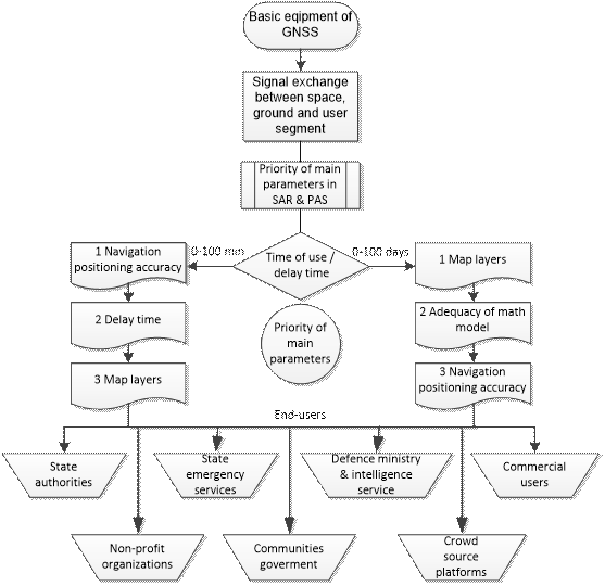
Fig. 3. Diagram of GNSS usage process in
safety applications (PAS – protection and safety aims)
References
1
Akinode J.
2011. "Improving national security using GPS tracking system technology". Mediterranean Journal of Social Sciences 2: 75-86.
Available at:
http://mcser.org/images/stories/mjss-special-issues/mjssvol2no5.pdf#page=75.
2
Anon C. 1994. "GPS/GIS applications for emergency
response". Public
Works 125(10): 96-98.
3
Assir R.El. 2011. Global navigation satellite systems and their wide range
of applications. inside
GNSS. Available at:
http://www.insidegnss.com/special/elib/rohde&schwarz_whitepaper_gnss+appl_2012.pdf.
4
Aven T., O. Renn. 2019.
"Some foundational issues related to risk governance and different types
of risks". Journal
of Risk Research: 1-14. DOI: https://doi.org/10.1080/13669877.2019.1569099.
5
Barnes R.J.H., J. Clapp. 1995.
"Cospas-sarsat: a quiet success story". Space Policy 11(4): 261-268.
DOI: https://doi.org/10.1016/0265-9646(95)00027-a.
6
Charles J. 2010. An introduction to GNSS. Novatel Inc. Available at:
http://www.novatel.com/assets/documents/books/an_introduction_to_gnss.pdf.
7
Devi D.A., B.V. Nayak. 2017. "Women employee
security system using GPS and GSM based person tracking". International Journal of
Professional Engineering Studies VIII(4):
331-337.
8
Fontanier M., H. Ruiz, C. Scaleggi. 2019. "Space operations: inspiring
humankind’s future". In: Pasquier H., C.A. Cruzen, M. Schmidhuber, Y.H. Lee (eds.). Space
operations: inspiring humankind’s future. Cham: Springer International Publishing.
DOI: https://doi.org/10.1007/978-3-030-11536-4.
9
Ilčev S.D. 2018.
"Cospas-Sarsat GMSC System". In: Global mobile satellite
communications applications: 305-371. Cham:
Springer International Publishing. DOI: https://doi.org/10.1007/978-3-319-71858-3_4.
10 Konopka E., P. Górski, L. Tarczyński, T. Chmielewski, P. Breuer. 2013. "Investigations of dynamic characteristics
of a tall industrial chimney due to light wind and solar radiation". Budownictwo i Architektura 12:
87-94.
11 Kristian Y., H. Armanto, M. Frans. 2012.
"Utilizing gps and sms for tracking and security lock
application on android based phone". Procedia - Social and Behavioral Sciences 57:
299-305. DOI: https://doi.org/10.1016/j.sbspro.2012.09.1189.
12 Lee S., I. Jeong, W.-G. Ahn. 2019. "Study on search and rescue system for military and civil use
by using cospas sarsat and terrestrial communication network". E3S
Web of Conferences 94:
01018. DOI: https://doi.org/10.1051/e3sconf/20199401018.
13 Lu W., F. Rodríguez,
E. Seignez, R. Reynaud. 2015.
"Lane marking-based vehicle localization using low-cost gps and
open source map". Unmanned Systems 03(04):
239-251. DOI: https://doi.org/10.1142/s2301385015400014.
14 Montenbruck O., P. Steigenberger, A. Hauschild. 2018. "Multi-GNSS signal-in-space range error assessment – methodology
and results". Advances
in Space
Research 61(12):
3020-3038. DOI: https://doi.org/10.1016/j.asr.2018.03.041.
15 Muthoni Njeru E., A. Imwati. 2016. "GPS & GIS in road accident mapping and
emergency response management". IOSR Journal of Environmental Science, Toxicology and Food
Technology 10(10): 75-86. DOI:
https://doi.org/10.9790/2402-1010017586.
16 Ogaja, C. 2011. Applied GPS for engineers and project managers.
17 ptolemus
Consulting Group. 2014. "Using mobile
phone GNSS positioning for 112 emergency calls?". Brussels, 7th may 2014.
18 Skorupa B. 2019. "The problem of
gnss positioning with measurements recorded using android mobile devices".
Budownictwo i Architektura 18(3):
51-62. DOI: https://doi.org/10.35784/bud-arch.738.
19 Wadhe P., R. Pandharkar, R. Raut, D. Modi. 2016.
"Emergency service using GPS tracking".
International
Journal of
Advanced Research in Computer and
Communication Engineering 5(4): 534-537. DOI: https://doi.org/10.17148/ijarcce.2016.54133.
20 Wang W., S. Wang. 2019. "Overview of the
international satellite-based cospas-sarsat system". Space Information Networks 972:
52-61. Singapore: Springer Singapore. DOI: https://doi.org/10.1007/978-981-13-5937-8.
21 Wankhede D.A. 2018. "Location based emergency medical services
using android mobile os". International
Journal for Research in
Applied Science and
Engineering Technology 6(4): 4689-4692. DOI:
https://doi.org/10.22214/ijraset.2018.4770.
22 Woolley A., J. Ewer, P. Lawrence, A. Travers, S. Deere, T. Whitehouse. 2016. "A modelling and
simulation framework to assess naval platform integrated survivability". Maritime/Air Systems &
Technologies: 21-23.
23 Yao H.W., W.L. Dong, D. Liang, A. Rogner, J.W. Lai. 2011. "Application of GIS
on emergency rescue". Procedia Engineering 11:
185-188. DOI: https://doi.org/10.1016/j.proeng.2011.04.645.
Received 01.08.2020; accepted in revised form 05.11.2020
![]()
Scientific
Journal of Silesian University of Technology. Series Transport is licensed
under a Creative Commons Attribution 4.0 International License