Article
citation information:
Mrozik, M. Analysis of aircraft
delays in FIR Warsaw in the context of radionavigation systems. Scientific Journal of Silesian University of Technology. Series
Transport. 2019, 102, 131-140.
ISSN: 0209-3324. DOI: https://doi.org/10.20858/sjsutst.2019.102.11.
Magda
MROZIK[1]
ANALYSIS OF AIRCRAFT DELAYS IN FIR WARSAW IN THE CONTEXT OF RADIONAVIGATION SYSTEMS
Summary. The paper contains an
analysis of the causes of aircraft delays at the main airports in Poland. Due to the fact that for several years there has been a large increase in
the volume of air traffic, generates operational and organisational problems
related to aircraft servicing, both at the airport and in the air. Due to the PBN STAR procedure, it is possible
not only to make more efficient use of the airspace, such as route layout,
reduction of flight time by at least 2 min, reduction of separation but also to
reduce the amount of harmful substances produced by the aircraft. When performing RNAV GNSS air operations, an
aircraft saves approximately 275 kg of fuel per flight, which has a significant
impact on environmental protection.
Keywords: aviation, PBN,
radionavigation systems
1. INTRODUCTION
Aviation is one of the
most dynamically developing areas of transport. For several years now, there
has been a large increase in air traffic both in Europe and all over the world.
The emergence of new air carriers, the creation of new international or
intercontinental connections generates operational and organisational problems
related to aircraft maintenance at the airport and in the air. These problems
affect the punctuality of air operations. However, delays are also generated by
independent reasons such as the weather. Unfavourable weather conditions contribute
more than 50% to the change in the flight schedule of aircraft. A bad
meteorological situation can disrupt or even paralyse air operations. The
aircraft take-off and landing procedure depends on the state of the weather. By
reducing the impact of operational factors, the aim is to increase air
capacity. As a result, programmes have been formulated in Europe for the
efficient management of air transport. One such project was the Single European
Sky (SES) initiative and the creation of the Single Sky Committee (SSC). The
SCC consists of civil and military representatives of the Member States, whose
primary objective is to assist the European Commission in the implementation of
the SES project. Based on the effect of unsatisfactory results, the programme
was modernised several times by establishing SES II and SES II+. The programme,
inter alia, strengthens the network management function, enhances the
competence of EASA in the context of safe airport operations and traffic
management, and introduces interoperability of the European air traffic
management network. SES II also introduced a new traffic surveillance
programme, SESAR (Single European Sky ATM Research). Its main objective is to
develop Air Traffic Management (ATM) procedures and technologies that will
contribute to reducing delays and the negative impact of aircraft on the
environment, as well as to increasing airspace and airport capacity. In
connection with the effectiveness of the implemented assumptions, it was
assumed that in 2020, among others, ATM costs will be reduced by 50%, the
negative impact of aviation on nature will be reduced by 10% or capacity will
be increased threefold while safety will be improved[2].
It should be kept in mind that SESAR proposes the implementation of new
navigation systems and aids such as GNSS as one of the main ways to optimise
aircraft routes and increase airspace capacity.
2. ANALYSIS OF MAIN AIRPORTS AT FIR
WARSZAWA IN TERMS OF AIRCRAFT DELAYS
Flight Information
Region Warsaw (FIR Warszawa) is a defined area of airspace in which flight
information service and emergency services are provided[3].
In Poland, air traffic management is the responsibility of the Polish Air
Navigation Agency. FIR Warsaw includes the Polish airspace (over the land area,
internal waters and territorial sea) and the ICAO-determined part of the Baltic
Sea space, which is delineated by a line of defined geographical points. The
Flight Information Region is classified as a controlled and uncontrolled area. In
the controlled area of the aircraft, an ATC (Air Traffic Control) service is
provided which regulates the flow of air traffic and prevents collisions of
aircraft during air operations. This area includes the airways controlled by
the ACC area control service, the TMA controlled area checked by the APP
Approach Control Unit and the CTR controlled areas of airports where traffic
control is exercised by the TWR Airport Control Tower. In the uncontrolled
area, information is provided to the aircraft through the Flight Information
Service (FIS). There are five FIS sectors in the Republic of Poland:
-
Warsaw (119,450 MHz).
-
Olsztyn (118,775 MHz).
-
Poznań (126,300 MHz).
-
Gdańsk (127,150 MHz).
-
Kraków (119,275 MHz).
Operational Air Traffic Controllers (OATs) are responsible for the
operation of military aircraft.
Figure 1 shows the CTR-controlled areas together with the operational
information for EPKT airport. Figure 1 shows that the CTR-controlled areas of
the following airports in Poland are included in the CTR-controlled areas:
-
EPGD (Gdańsk-Rębiechowo).
-
EPSC (Szczecin-Goleniów).
-
EPSY(Olsztyn-Mazury).
-
EPBY (Bydgoszcz-Szwederowo).
-
EPPO (Poznań-Ławica).
-
EPMO (Warsaw-Modlin).
-
EPZG (Zielona Góra-Babimost).
-
EPWR (Wrocław-Strachowice).
-
EPWA (Chopina w Warszawie).
-
EPLL (Łódź-Lublinek).
-
EPRA (Radom-Sadków).
-
EPKT (Katowice-Pyrzowice).
-
EPKK (Krakow-Balice).
-
EPRZ (Rzeszów-Jasionka)
-
EPLB (Lublin).
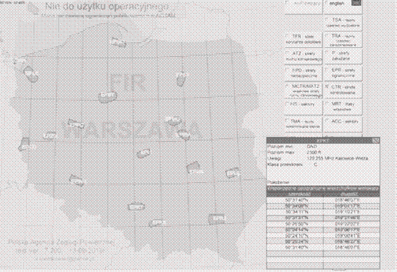
Fig. 1. Controlled areas
of TMA airports
source: http://www.amc.pansa.pl
Figure 2 shows the FIS Air
Information Service in the area of the FIR EPWW.
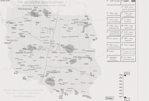
Fig.
2. Flight Information Services in the area of the FIR EPWW
source:
http://www.amc.pansa.pl
In order to monitor the
situation in the Polish sky, the Polish Air Navigation Agency issues an annual
report on air traffic at FIR Warsaw. On the basis of this document, the
analysis of delays at major airports in 2017 was made: Gdańsk
Rębiechowo, Krakow Balice, Katowice Pyrzowice, Poznań Ławica,
Rzeszów Jasionka, Szczecin Goleniów, Chopin in Warsaw,
Wrocław Strachowice, Zielona Góra Babimost, Bydgoszcz Szwederowo,
Łódź Lublinek, Warszawa Modlin, Lublin Świdnik, Radom
Sadków and Olsztyn Mazury.
From the published data
it shows that 457,913 operations were carried out at the airports listed above,
an increase of 10.3% compared to 2016. The highest number of operations was
recorded at Warsaw Chopin Airport (37.8%), Krakow Balice (11.7%) and
Gdańsk Rębiechowo (9.5%). Figure 3 presents a detailed percentage
share of individual airports in the air operations in 2017 [3].
The significant increase in the number of aircraft operations handled
contributed to the aircraft delays already generated both on the ground and in
the air.
According to the PAŻP report, the average delay per flight
operation was 0.2 min per flight, of which enroute (on the route) was 0.1 min
per flight.
Analysing the data from the report at the turn of 2002-2017, the biggest
increase in delays was observed in 2007 and 2008. Compared to last year, when
the average delay was 0.5 min per flight, the delay was reduced by 0.3 min per
flight.
Figure 4 shows the relationship between traffic delays and traffic
volumes from 2002 to 2017.
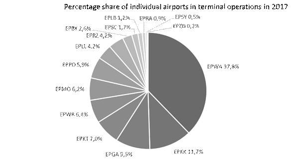
Fig. 3. Percentage share
of individual airports in terminal operations in 2017
source: own elaboration
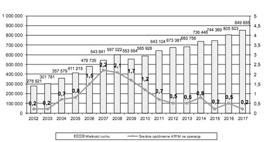
Fig. 4. Volume of
traffic and delays in FIR Warsaw in 2002-2017
source: [3]
In continental terms, Poland was ranked fourteenth in terms of
generating all the delays. France (24.5%), Germany (18.5%) and the United
Kingdom (11.5%) were among the countries with the highest delays.
Aircraft delays can be caused by natural (for example, weather
conditions) or artificial (for example, lack of manning) factors. The reasons
for subsequent departures can also be classified according to the space
concerned, that is, the airport and the route. The size of the delay rate
generated at the airport is influenced by such elements as:
- lack of
staffing.
- aerodrome
capacity.
- airspace
management.
- weather.
- equipment.
- ATC and
aerodrome capacity.
- special
events.
- other.
On the other hand, these contribute to delays on the aircraft route:
- weather
conditions.
- equipment.
- ATC
capacity.
- protest
activities not related to ATC (industrial action non-ATC).
- lack of
ATC staffing.
- other.
According to data published by the Polish Air Navigation Agency, in 2017
airports contributed to 28,570 min of delays. On the other hand, factors
occurring on the route caused 87,644 min of delay. Figure 5 illustrates the
percentage share of the different factors causing delays at airports. The
presented data indicates that in over 50% unfavourable weather conditions such
as fog, volcanic eruption, storms or turbulence affect 14,623 min of aircraft
delay. Another factor determining irregularities in air operations is the
capacity of the airport, which is responsible for 7,946 min of delay.
Meanwhile, ATC equipment had the least effect on the later departure of the
aircraft (85 min).
Figure 5 shows the percentage share of factors causing delays at the
airport in 2017.
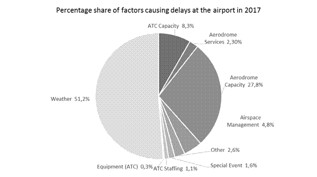
Fig. 5. Percentage share of factors causing delays at the airport in
2017
source: own elaboration
Figure 6 presents the same graph as Figure
5 illustrating the percentage share of elements causing aircraft delay on the
route.
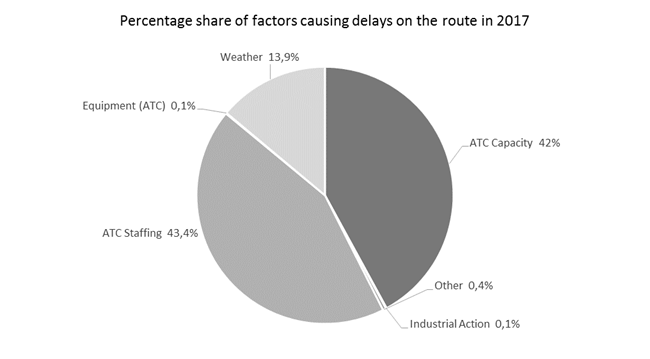 Fig.
6. Percentage share of factors causing delays on the route in 2017
Fig.
6. Percentage share of factors causing delays on the route in 2017
source: own
elaboration
On the basis of the
above data, it can be concluded that in 2017 the main factor affecting the
subsequent take off of aircraft was the lack of adequate level of human
resources. It contributed to a delay of 38,055 min. A comparable effect (42%)
had the capacity of ATC, which led to 36,853 min delay.
Comparative analysis of
both charts (Figures 5 and 6) shows that the equipment had minimal impact on
aviation operations. The capacity of both the ATC and airports proved to be
problematic.
Factors belonging to other
groups and special events must also be taken into account. Events such as the
closure of the airspace during the NATO summit, the increase in air operations
during the World Youth Day in Krakow or the political situation in Ukraine in
2016, contributed to the unpredictable growth in traffic and the generation of the
high rate of delays.
3. SATELLITE SYSTEMS AND AIDS AS TOOLS TO REDUCE AIR
TRAFFIC DELAYS
The number of
implemented methods of delay reduction is increasing yearly. Airlines,
operators, airport managers or aviation authorities such as PAŻP or ICAO
strive to minimise delays in air operations. One such tool is the PBN
(Performance-Based Navigation) concept. In 2008, ICAO issued the Doc 9613
"Performance-based Navigation Manual", which builds on the Required
Navigation Performance (RNP) concept and obliges ICAO member countries to
develop the plans for the above project. A PBN is an area navigation based on
characteristics that allow the position of an aircraft to be determined with
precise accuracy for a particular phase of flight. This is possible because of
a navigation system (for example, GNSS) that meets guidelines such as accuracy,
functionality, integrity, availability and continuity. Through the use of PBN,
it is allowed to fly on any designated route within the range of the ground
navigation systems or the limits of the capability of autonomous devices or
with the integration of both. The concept in question cooperates with many
aviation entities: pilots, training centres, airport managers and air
operators, aircraft manufacturers, as well as the authorities responsible for
air traffic control and airspace management. The PBN comprises of two types of
navigation specifications, which are a set of requirements necessary for the
execution of flights within a defined airspace structure, namely RNAV (aRea
NAVigation) and RNP (Required Navigation Performance). In the RNAV
specification, it is necessary to maintain the required navigation accuracy
(for example, RNAV 2 ) and to meet the requirements for consistency, continuity
as well as the functionality criterion (for example, installation of an
on-board database). Aircraft equipped with a GNSS system, the RNP obtain
through a Receiver Autonomous Integrity Monitoring (RAIM) receiver. In addition
to the conditions for RNAV, the RNP also has a criterion for on-board
monitoring of navigation accuracy and alarming. Navigation based on
characteristics integrates elements such as navigation specifications,
navigation applications and radio navigation infrastructure.
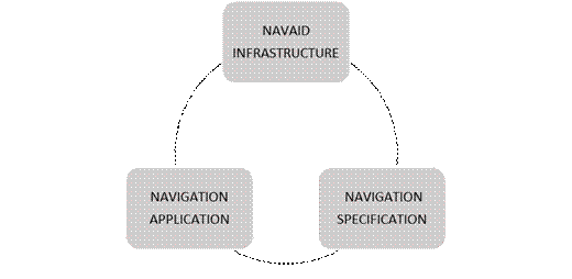
Fig. 7.
Elements of the PBN concept
source: own
elaboration
Radionavigation
infrastructure includes terrestrial navigation aids (VOR, DME) and satellite
navigation systems (GNSS: GPS, Glonass, Galileo).
The use of area
navigation offers many benefits to air transport, including minimising delays
in air operations. The most important ones are:
- reduction
of separation for all phases of flight. Where airspace becomes more crowded,
PBN allows the most efficient use of space through an appropriately managed
reduction of separation and flight track along the route, during approach and
landing.
- reduction
of ATC and flight crew load (pilot-ATC communication will be reduced by up to
70%).
- rationalisation
of the radionavigation infrastructure through optimisation of the terrestrial
equipment of satellite systems (investment projects, costs).
- lower
fuel consumption of aircraft. By minimising approach and landing routes, the
aircraft's fuel demand is reduced.
- reduction
of CO2 emissions. By optimising fuel consumption, the amount of
harmful substances emitted by the aircraft is reduced, which contributes to
environmental protection.
- reducing
the interdependence factor of terrestrial radionavigation infrastructure. The
PBN concept is based primarily on GNSS. Such a solution makes it possible to
reduce terrestrial navigation devices and thus their cost of maintenance and
care.
- the
introduction of so-called “global harmonisation”. The PBN project
is used all over the world by ICAO member states (192 countries). This means
that the certification of operators and aircraft can be unified.
- reducing
delays in air operations. Through more effective airspace management and more
precise data such as aircraft position data, the punctuality rate of aircraft
increases.
These advantages
indicate that the RNAV GNSS system can be used not only as a tool to reduce
aircraft delays but also on other planes, including environmental protection.
4. SUMMARY
The dynamic growth in
air operations contributes to the continuous modification of existing
procedures. In order to minimise the negative impact of congested airspace, new
methods of efficient space management are being sought. One such tool is the
implementation of the PBN concept, which creates many opportunities for
aviation. As mentioned in the article, aircraft delays are serious problems for
the air transport. The implementation of this system allows for an increase in
air capacity, which in turn affects punctuality, and also reduces CO2
emissions. The fact that RNP rules enable aircraft to be located more
accurately is also a key element in improving safety. On the basis of the
published data, it can be concluded that, despite the intensive growth of air
operations, the aircraft delay rate in Poland is at an acceptable level on continental
terms. Poland was only responsible for less than 1.0% of all delays. It should
be remembered, however, that despite the development of aviation techniques, it
is still the independent factors such as atmospheric conditions that affect
more than 50% of all flight operations
References
1.
Annex 2 to the Convention on International Civil Aviation (Rules of the
Air).
2.
Banaszek Krzysztof, Marek Malarski. 2011.”Position accuracy of
modern satellite navigation systems and airport capacity”. Logistyka 80: 48-67.
3.
Civil Aviation Authority. Available at: http://www.ulc.gov.pl.
4.
Dudek Ewa. 2018. “The concept of DMAIC methodology application for
diagnostics of potential incompatibilities in aeronautical data request
process”. Diagnostyka 19(4):
33-38. DOI: 10.29354/diag/93963.
5.
Fellner
Andrzej. 2016. Nawigacja powietrzna w
zarysie. [In
Polish: Air navigation in outline]. Gliwice: Silesian University of
Technology. ISBN: 978-83-7880-346-1.
6.
Fellner
Andrzej, Radosław Fellner, Henryk Jafernik. 2016. Wykonanie lotów IFR i podejść według PBN. [In Polish: Execution of IFR flights and approaches
according to PBN]. Gliwice:
Silesian University of Technology. ISBN: 978-7880-357-7.
7.
Fellner Radosław, Henryk Jafernik. 2015. Aeronautical regulations in exercises. Gliwice: Silesian University of Technology.
ISBN: 978-83-7880-326-3.
8.
Fellner Andrzej, Jafernik Henryk. 2016. “Implementation of
satellite techniques in the air transport”. Rep. Geod. Geoinformat 100(1): 39-53. ISSN: 2391-8365. DOI: https://doi.org/10.1515/rgg-2016-0005.
9.
Fellner Andrzej. 2016. “Application of the Global Navigation
Satellite System (GNSS) in air navigation”. Report to Committee on Space Research (COSPAR). Polish Space Agency:
24-28.
10.
Hensher David. 2015. “Value of travel time savings and value of
trip time reliability: a concern”. Road
& Transport Research: A Journal of Australian and New Zealand Research and
Practice 24(4): 73-74.
11.
International Civil Aviation Organization. 2008. Performance-based Navigation (PBN) Manual. Doc 9613 AN/937.
12.
International Civil Aviation Organization. 2006. Procedures for Air Navigation Services Aircraft Operations. Volume II
– Construction of Visual and Instrument Flight Procedures. Montreal.
Doc 8168
13.
International Civil Aviation Organization. 2005. Global Navigation Satellite System (GNSS) Manual. Doc 9849 AN/457
14.
International Civil Aviation Organization. 2016. Doc 4444 (PANS-ATM, or
Procedures for Navigation Services – Air Traffic Management).
15.
Polish Air Navigation Services Agency. Available at: http://www.pansa.pl.
16.
Polish Air Navigation Services Agency.2017. Annual Report 2017. [STAT/ASM/17].
17.
Rosłoniec
Stanisław. 2017. Podstawy
radiolokacji i radionawigacji. [In Polish: Basics
of radiolocation and radio navigation]. Warsaw: WAT. ISBN: 78-83-7938-166-1.
Received 08.11.2018; accepted in revised form 12.01.2019
![]()
Scientific
Journal of Silesian University of Technology. Series Transport is licensed
under a Creative Commons Attribution 4.0 International License