Article
citation information:
Abid, N.M., Al-Khazraji A.J.M. Urban
growth and spatial development along transport corridors in Dujail Municipality.
Scientific Journal of Silesian University
of Technology. Series Transport. 2018, 101,
05-14. ISSN: 0209-3324. DOI: https://doi.org/10.20858/sjsutst.2018.101.1.
Nada Mohammed ABID[1], Adil Jasim Mohammed AL-KHAZRAJI[2]
URBAN GROWTH AND
SPATIAL DEVELOPMENT ALONG TRANSPORT CORRIDORS IN DUJAIL MUNICIPALITY
Summary.
Often, most cities grow as a result of the increase in population in addition
to increased urbanization in developing cities, including in Iraq. Where urban
growth is defined as a set of phenomena, which offers geographical, economic,
social and administrative advantages in terms of attraction and influence, the
areas associated with them tend to suffer from population concentration and
accumulation in productive activities and services. This results in social
impacts on an economic, geographical and administrative scale in the region
itself and its surroundings [4]. Usually, growth sites in the city are places
where development is feasible with the lowest possible costs on flat land and
close to infrastructure services, especially transport corridors.
Keywords: urban corridor; city development;
spatial effect
1. INTRODUCTION
Research problem: The urban
growth of cities in scattered centres (the distance between the centre is
unequal and not equal in size) along the main transport corridors passing by or
near them. This leads to cities forming along the length of these corridors
without a threshold to prevent the subsequent negative effects. Research goal:
To highlight the phenomenon of planned and unplanned growth along the main
corridors and transport facilities that pass through or near cities and their
negative effects on these cities. Research hypothesis: An artificial threshold
must be established to prevent the growth of cities scattered along roads or
near transport corridors, which affects the shape of the city, leaving a
negative impact on providing infrastructure services and resulting in a lack of
a clear centre for neighbourhood services [4]. One should remember
about human factors, including safety-related issues
[12-18].
2. FACTORS OF URBAN GROWTH
2.1. Population
factors
A. Population
growth: The world population growth rate was very slow until the early 20th
century. This decline was due to the high mortality rate, reflecting a decline
in natural increase. This decline was linked to many factors, including
famines, epidemics, wars and their effects. Since the revolution in agriculture
in England and some European countries prior to the first census in the seventh
century, a number of factors has led to an increase in the population in these
regions. Meanwhile, the world population in the first century CE was about
200-300 million people, but this had increased to 500 million by 1650. The
number doubled to one billion in 1850 and then doubled again to two billion in
1930 [6].
We can say that
population growth is due to the following:
1. Increase in the number of
births compared with deaths
2. Internal migration from
rural to urban areas
3. Foreign migration, i.e.,
from outside the state
With the emergence of the Industrial
Revolution and the resulting prosperity, the means of production and transport
were improved, with relative stability, and are considered to be have been
important and fundamental factors leading to the growth in population in the
West. There arose the theory of Maltose in the period 1802-1800, warning of the
dangers and consequences of population growth and the conflict between it and
available food resources. The rate of births in Western Europe subsequently
began to descend from 1850, alongside progress in the field of health,
resulting in the immunization of diseases and epidemics in particular.
Meanwhile, war had a significant impact on the delay in population growth in
the pre-industrial era, while the First and Second World Wars led to the
mobilization of young people in the armed forces and a decrease in birth rates.
The First World War recorded a loss of 7.3 million people and the Second World
War recorded a loss of 7.2 million people [9]. The modern population boom
resulted from a large natural increase with a decrease in the mortality rate
and steady or low birth rates in some countries of the world. Statistics have
shown that the decline in mortality is the main cause of rapid population
growth in modern times, with the average life expectancy of individuals in most
countries being due to the favourable conditions of health, thanks to
scientific progress in the medical and pharmaceutical fields. Arab countries
have witnessed a rise in the rate of natural increase in recent decades,
ranging from 2.4% in some countries to 4% in others. Yemen recorded the lowest rate
of natural increase, amounting to 2.4%; and, if this increase continues at the
same rate, then it will be doubled in a quarter a century [10].
B. Migration: This is a major
component of population studies because it is considered as the second source of
urban growth and the change in the size of populations and cities after natural
increase. Migration is a social and geographical phenomenon characterized by
human movement over time. It means moving or traveling from one place to
another and living there for a long or short period. The transfer of persons
from one geographical area to another is concerned with changing the place of
permanent residence, as well as cross-border movements, except for tourist
movements [7]. Migration comes in several types, such as international or
internal migration, and encouraged or forced.
2.2. Political and military factors
The administrative
arrangements that accompanied the development of patriarchal sovereignty
towards tribal sovereignty, the coordination of relations between individuals
in society, the monitoring of security matters, and the enactment of legal and
social controls were key factors in the emergence of cities. Political power
has played a distinct role in the formation and construction of cities. Governments
often choose to locate their centres in cities [10].
2.3. Cultural factors
This includes the arts, ethical
trends, historical conditions, doctrine, taboos, the sanctities of technology
and urbanization. All of these affect the distribution of populations and
services and play a major role in the emergence of cities, as well as how human
culture informs the creation of cities and changes the morphology and physical
form. Thanks to these cultural factors, cities have grown beyond their cultural
structures to provide luxury.
2.4. Economic factors
Economic factors
are a set of phenomena related to the physical life of societies. They include
elements that produce goods and services, such as natural resources, land,
capital, means of production, cultural values, technical knowledge,
organization, labour, skills and personnel techniques, industry and its
organization, urbanization and welfare levels. Goldsmith has divided economic
growth into five stages
The first is the
economy, which is based on roaming from one place to another: in the past, man
was dependent on collecting fruit and fishing, followed by the stage of
collecting fruit and hunting animals, with relative stability on the ground.
This transition represents the development of society. The third stage was to
rely on agriculture, grazing and animal husbandry. The fourth phase was
characterized by the growth in agriculture and prosperity, along with a surplus
sufficient to support the urban population. The fifth stage saw the emergence
of more complex work, while we can add a sixth stage involving the emergence of
a technology and information economy. This economic growth has led to a
population increase and consequently the growth of cities. Montesquieu
considered the city to be part of the economic system [5, 6].
3. URBAN GROWTH THEORIES
3.1. Ernest
Burgess’ theory of concentric circuits
Ernest Burgess made
a remarkable contribution to the influence of early ecologists and contributed
to the writing on city growth. Burgess was interested in the development of
ecological theory. In order to evaluate this theory, he developed a model and a
graphic description of the way the city is growing and its spatial organization
using an ecological map of the city of Chicago. To this map, he fixed its growth
in light of its physical extension and its differentiation in terms of place,
stemming from the basic idea that land prices and accessibility are maximized
in the heart of the commercial city and then decrease away from the central
area. This confirms that land prices and accessibility are paramount in the
city, while “the city in its growth takes five concentric rings or
concentric or concentric domains”, which are as follows:
1. The central business
district
2. Transition zone or
transformation
3. Workers’ housing area
4. The best residential area
5. Daily or suburban travel [5]
3.2. Sector theory
This theory emerged
at the end of the 1930s as a reaction to the many criticisms of the theory of
concentric circles. This was at the hands of Homer Hoyt, who presented a
conceptual framework, in which the ecological pattern was determined in light
of the idea of sectors, after studying 142 cities in terms of rents and
explaining the nature of dwellings and their advantages. This theory states
that the city is divided into sectors not rings. He stated that social housing
is based on rental values. The latter also highlights the fact that it is
income that determines the housing of individuals. The internal structure of
cities is the way out of its centre to the other parties and arranges
residential areas into three main sectors. Alongside commercial activities in
the city centre areas, these sectors are:
1.
Low-rental sector including workers with limited incomes
2. Mid-rental sector including
middle-income individuals
3. High-rental sector including rich people
with high incomes
3.3. The theory of
multiple nuclei
This resulted from criticism
of the theory of concentric circles and sectors. Harris and Ullman advocated
this theory and stated there is a number of centres in the city, rather than
just one centre, and that each city is different from the other in terms of the
types and number of centres. Harris and Ullman pointed to four factors
affecting the distribution of activities, i.e., the establishment of their
centres [5].
4. THE ROLE OF TRANSPORT IN THE GROWTH AND
EXPANSION OF THE CITY
The basic function of
transport highlights the integration of human activity in the place where the
exchange of products and activities, as well as the distribution of people,
energy and goods, takes place. As transport is a key mechanism for the
integration of the results of the ecological division of labour and activity,
it can be one of the constraints that greatly affect the integration process
and its results. In light of ancient and medieval history, we find much
evidence of societies that flourished in becoming civilized, which enabled them
to invent and develop appropriate transport mechanisms and connect with other
societies that were isolated from human civilization because of their spatial
isolation. The most effective means of transport were developed and isolated
communities began to communicate through trade processes. By making links with
activities and products of individuals who were located in various places, the
first signs of urban growth and extension were witnessed, leading to an
increase in the size of the urban population. In any case, the technological
revolution was the starting point for urban growth in modern times.
5. STUDY AREA INFORMATION
The city of Dujail (the centre
of the Dujail District) was a rural settlement in the Ottoman period. It was
then developed and expanded by the national government. It became a district
known as Smika, under Samarra’s royal decree, in 1925 [2]. The name was
then changed to Ibrahimia, after which the name was changed to Dujail, due to
its closeness to the former Dujail River (this river no longer existed after
the implementation of the Ishaqi irrigation project in the north-west of the
city. In 1989, under the Presidential Decree No. 366, Dujail became a city,
which included two districts, named Taji and Tarmiyah. These two areas were
then separated and attached to the capital of Baghdad under Decree No. 222 in
1999, thus creating the district of Dujail without any administrative units.
The area of the basic design of the developed city area is 6 km2 and
the total area of the city of Dujail is 18 km2, with one third of
the land having been developed and containing urban activities. The remaining
two thirds comprise agricultural lands, most of which contain grape orchards,
with a population of about 35,000 [3].
5.1. The city of
Dujail
The city of Dujail is one of
the cities in the province of Salah al-Din, where the area of the basic design
of the city’s developed area is 6 km2, with a population of
about 35,000. It became a stable urban city in 1925 when the Smika District
became the area of Dujail.
5.2.
Urban land uses in the city of Dujail
Planners who are interested in
the study of cities refer to the term “land use”, which concerns
what functions (such as commercial, industrial, residential, transport or
recreational) are located on its land. Land use can involve human or natural
controls or both [6]. The city of Dujail is used for commercial uses, industrial
uses, residential uses and service uses. It is known that the scale of the uses
in the city varies according to the type of use, where residential use
represents the largest percentage of the city’s land use. According to
the functions of the city, the more the city has a major function, the greater
the impact on this area of use. For example, cities with tourism functions,
where tourism use is the leading role, or cities with industrial use, the
effect of this usage is clear. It is noticeable that growth in Iraqi cities
firstly involved residential use, followed by transport use, and then
commercial and industrial use. In the study area, the area within the municipal
boundaries covers about 2,400 acres, of which 48 acres are for commercial use,
representing 2% of the total area. Industrial use covers 169 acres or 7% of the
total, although only 1 acre is currently used and built factories are located
within an industrial zone, which has been cancelled due to the growth of the
city within residential areas in the southern part of the city, i.e., between
two residential quarters 204 and 206 in the Al-Zahra neighbourhood.
Recreational use covers 43 acres across 58 sites or 1.8% of total use, most in
the form of four parks and two football stadiums, while public buildings and
services cover an area of 123 acres across 45 sites or 5.1% of total use.
Residential use, as defined above, covers a total area of 1,557 acres (64.9%).
Table 1 and Figure 1 illustrate the above. In the study area, we find that
residential use ranks first, transport use comes in second place, industrial
use in third place and general service use in fourth place, while commercial
use ranks fifth and recreational use ranks sixth and last.
Table 1
Urban land use in the area
of Dujail City
|
Land use |
Area (acres) |
% |
|
Commercial |
48 |
2 |
|
Industrial |
169 |
7 |
|
Residential |
1,557 |
64.9 |
|
Recreational |
43 |
1,8 |
|
Public
services |
123 |
5.1 |
|
Transportation |
460 |
19.2 |
|
Total |
2,400 |
100 |
Source: Municipality of Dujail
Planning Department
Based
on the above table, the percentage shares of land use are plotted (see Figure 1).
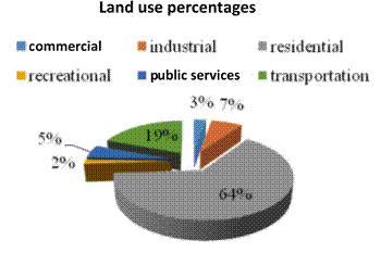
Fig. 1. Urban land use percentages for the urban area of Dujail City
Source: Based on the data in
Table 1
5.3. The development
stages for the city of Dujail during the age of the modern Iraqi state
The city of Dujail
has undergone four stages of development and, since 1925, the first royal
recognition has emerged as a city, as follows:
The first phase: The centre of the
city was considered a centre of a district in 1925 known as the Smika District.
This year was the starting point of the first phase until 1944. The city before
this was known as the Smika area and consisting of five provinces (24, 25, 26,
27 and 28). The areas are coloured brown in Figure 2 and covered an area of 9.1
ha.
The second phase: This covered the
period 1944-1969, during which the city expanded its surroundings into a large
province. This was considered a district (22, indicated in yellow, in Figure 3),
while the expansion area of 37.7 ha became part of the city’s total area
of 56.9 ha.
The third phase: This covered the
period 1969-1983, when the city expanded to include parts of the province (nine
Tall Maskins) as shown in pink in Figure 3. The area of expansion reached 80.4
ha, meaning that the city’s total urban area became 137.2 ha. At the same
time, the main street in the city of Dujail was composed of several nuclei: the
first nucleus was 2 km south-east of the city and the other nuclei were a triangle
near the train station.
The fourth phase: This runs from
1983 until the end of 2017, during which the city expanded in some of the
agricultural districts (nine Tall Maskins, 16 Halis, 18 eastern orchards, 19
middle orchards, 20 northern orchards and 21 southern orchards), with an area
of 382.5 ha, making the total urban area equal to 519.8 ha, with the total
design area being 1,840.3 ha. This was the largest expansion of the city after
the events of 1982, when it reached 1,703 ha. Meanwhile, the area used for the
urban expansion of the city equated to 383 ha or 28.24% of the total design
area, with the rest (71.76%) comprising agricultural land, 65% of which is
arable and 35% unsuitable for agriculture. Given the exposure of the earth to
direct sunlight, without cultivation and rising groundwater, this has caused
significant amounts of salts from the ground to settle on the surface,
rendering the land unsuitable for agriculture. By observing the stages of urban
growth in the city, we find that, with the development of the means of
transport, the city has grown along the main street with two large nuclei,
allowing the city to grow in the final stage, as shown in Figure 2, with a
longitudinal form consisting of five neighbourhoods and 15 residential quarters
spread sequentially along the street. This runs from the main city of Dujail to
the Baghdad-Mosul Regional Road before reaching Dujail Railway Station as shown
on the map.
Fig. 2. Design of the urban area of
Dujail 2017
Source:
Dujail Municipality Department of Urban Planning/
As a result, the growth is
lava-like, meaning it is scattered over uneven distances and across unequal
sizes. However, as we mentioned above, it has taken a clear pathway along the
main corridors (Dujail Main Street, Baghdad-Mosul Regional Road) and Al Qal
facilities (Dujail Railway Station). In spite of the benefits that result from
the growth near the transport corridors in the field of spatial development
(see Figure 3), in terms of easy access and job
opportunities, it is not without the following disadvantages:
•
The difficulty and cost of providing infrastructure
services such as water and sewage networks, electricity grids and paving of main
streets.
•
The absence of a clear centre for neighbourhoods,
while the scale of service provision in the neighbourhood is limited because of
the extension of residential quarters.
City development 1969-1983 City development 1983-2012 City development 1944-1969 City development 1925-1944
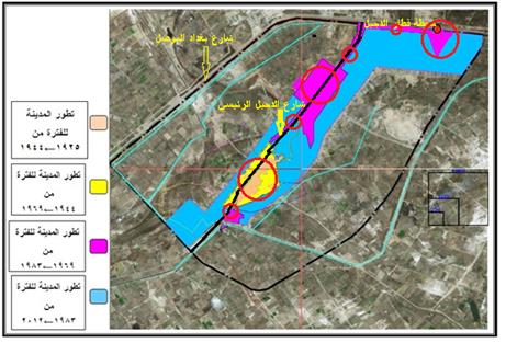
Fig. 3. The development stages of
the city of Dujail since 1925
Source: From the work of the
researcher, based on data from
the stages of the development of the city of Dujail
When looking at the
final shape of the urban area, and compared with the theories of growth, it
does not match any of them except in the first and second stages, where there
was no significant effect of transport in the formation of cities due to the
principle of theories of concentric circles being accepted. However, the third
and fourth stages, which saw spread and growth, made the centre become uncertain
and longitudinal, i.e., taking the form of a transport corridor (Dujail Main
Street and Baghdad-Mosul Regional Street) with the largest lava-like urban
growth, as we mentioned, in the south-east of the city and near the train
station. This would appear to link the theory of multiple nuclei with the
nature of the spread and concentration. Thus, we see a clear role
for transport corridors and facilities in the formation of cities and the
nature of their growth when reviewing the stages of the development of the city
of Dujail. As the economic aspect has been one of the most important reasons
for the formation of cities in modern times, transport has one of the most
important drivers of economic development, allowing the population to move in
order to enhance quality of life and prosperity.
6.
CONCLUSIONS
1. There is an effective role for urban
corridors and facilities in the nature of cities and their stages of
development, especially after significant advances in the means of transport.
2. Despite the
positive role of the transport sector in the field of spatial development, the
negative effects could surpass the positive effects, and this is what we have
seen in the stages of growth and formation of the city of Dujail, where the
city structure is bounded by the main street in the city, as well as
Baghdad-Mosul Regional Street, which has led to the following:
·
The lack of a clear centre for neighbourhoods to assign the services of
the neighbourhood because of the extension of residential quarters, which makes
the coverage area of the impact of public services for the neighbourhood are
few and do not cover all the neighbourhood.
·
The difficulty and cost of providing infrastructure services such as
water and sewage networks, electricity grids and paving of main streets.
3. The nature of
the city of Dujail may help to explain the formation of some cities based on
transport corridors and facilities, which could inform a new theory of urban
growth and detailed studies supporting this trend.
7.
RECOMMENDATIONS
1. Establish barriers that prevent the emergence of growth, such as
those witnessed in Dujail, as these can avoid the disadvantages that result
from such growth due to the strip shape of the city, although the third and
fourth stages of the development of the city were planned stages and not as
random as the first and second stages.
2. Prepare a study on costs and benefits should be undertaken in order
to determine the nature of the formation of cities located along main transport
corridors.
3. Consider the factors of the impact of transport in the development of
expansion strategies, so that we can evaluate the negative and positive
consequences of urban growth, when based on corridors and transport facilities.
This will reinforce the positive factors and reduce the negative effects of the
formation of cities as we have seen in the city of Dujail.
4. Strive to establish administrative or legal barriers that limit the
longitudinal growth of cities by issuing laws, instructions or regulations,
especially where such growth is supported by and in the interests of society,
and in turn the negative effects of such expansion, which usually appear after
long periods of time.
References
1.
Abdel M. 1981. Society
of the City. Libya: Dar al-Nahda al-Arabiya.
2.
Al-Dujail District Court. Archives - Unpublished Data.
3.
Municipality of Dujail Department of Planning and
Follow-up.
4.
Hakim M. 1978. Urbanization
in the Arab World, Arab Organization for Culture and Science, League of Arab
States. Cairo: Egyptian General Libraries.
5.
Hamid K., S. Belkacem, K. Ismail. Theoretical Problems and Reality. Constantine: Montessori
University Press.
6.
Hussein R. 1998. The
City. Alexandria: The Modern University Office.
7.
Hussein R. 2002. The
City. Alexandria: The Modern University Office.
8.
Hussein A. 1973. The
Rise and Development of Iraqi Cities. Ataba Printing Press.
9.
Fathi A. 2000. Studies
in Demography. Beirut: Dar al-Nahda al-Arabiya.
10.
Tamadr H., R. Hussein. Security Problems Associated with the Growth of Al-Muhannad and
Al-Hijjah. Riyadh: The Arab Center for Security Studies and Training.
11. Taha A. 2005. Master of Urban Land Use Introduction to the
Faculty of Education. Ibn Rushd.
12.
Czech P. 2017. “Physically disabled pedestrians
– road users in terms of road accidents”. In Macioszek E.,
Sierpiński G. (eds.), Contemporary Challenges of Transport Systems and
Traffic Engineering. Lecture Notes in
Network Systems Vol. 2: 157-165. Springer.
13.
Bivina G.R., Purnima Parida, Mukti Advani, Manoranjan
Parida. 2018. “Pedestrian level of service model for evaluating and
improving sidewalks from various land uses”. European Transport \ Trasporti Europei. Issue 67. Paper n 2.
14.
Brumercik F., M. Lukac, Z. Krzysiak, L. Krzywonos.
2017. “Model of integrated transportation system”. Komunikacie 2: 23-26.
15.
Czech P. 2017. “Underage pedestrian road users
in terms of road accidents”. In Sierpiński G. (ed.),
Intelligent Transport Systems and Travel Behaviour. Advances in Intelligent Systems and Computing Vol. 505: 75-85.
Springer.
16.
Jacyna M. 1998. “Some aspects of multicriteria
evaluation of traffic flow distribution in a multimodal transport
corridor”. Archives of Transport
10(1-2): 37-52.
17.
Jacyna M., M. Wasiak, K. Lewczuk, M. Kłodawski.
2014. “Simulation model of transport system of Poland as a tool for
developing sustainable transport”. Archives
of Transport 31(3): 23-35.
18.
Sokolovskij E., O. Prentkovskis. 2013.
„Investigating traffic accidents: the interaction between a motor vehicle
and a pedestrian”. Transport 28(3):
302-312.
Received 26.08.2018; accepted in revised form 13.11.2018
![]()
Scientific
Journal of Silesian University of Technology. Series Transport is licensed
under a Creative Commons Attribution 4.0 International License