Article citation information:
Laskowski, J. Key technological solutions from the SESAR programme to
improve air traffic safety. Scientific
Journal of Silesian University of Technology. Series Transport. 2017, 94,
99-110. ISSN: 0209-3324. DOI: https://doi.org/10.20858/sjsutst.2017.94.10.
Jan LASKOWSKI[1]
KEY TECHNOLOGICAL SOLUTIONS
FROM THE SESAR PROGRAMME TO IMPROVE AIR TRAFFIC SAFETY
Summary. The
dynamic development of the air transport market has led to a significant
increase in air traffic in a highly fragmented and relatively small European
airspace. This situation could, in the near future, render the currently
functioning European air traffic management (ATM) system obsolete and incapable
of providing the high safety standards demanded by the ICAO and Eurocontrol.
Recognizing the urgency in finding a solution to this problem, the EU gas
launched the Single European Sky (SES) initiative, along with its technological
pillar, the Single European Sky ATM Research (SESAR) programme, which seeks to
enhance air traffic safety, support the sustainable development of the air
transport system and improve the overall performance of ATM and air navigation
services, so that they meet the requirements of all airspace users. This paper
presents a selection of the SESAR programme’s key technological solutions, such
as approaches based on area navigation (RNAV)/Global Navigation Satellite Systems (GNSS), and the “remote tower”
concept, which have been developed to maximize the safety and efficiency of the
new European ATM system.
Keywords: air traffic safety, SESAR
solutions, air traffic management (ATM) system, remote tower, RNAV (GNSS)
approach procedures
1. INTRODUCTION
Nowadays,
aviation is one the most dynamically developing branches of transportation,
with air transport driving global economic growth, employment, trade links and
tourism [2]. Each year, more than 37.4 million flights climb into the air
carrying about three billion passengers and nearly 50 million tons of freight
around the world [2]. In relatively small Europe, approximately 10 million
flights carry over 1.6 billion passengers annually, which emphasizes the
crowded state of the airspace over our heads [9]. Taking into account the
European Commission forecasts, air traffic in Europe is expected to more than
double in the next 20 years and even triple in some regions. Unfortunately, the
current ATM system is close to becoming obsolete and ill-suited for the rapid,
economic and reliable development of air transport in Europe. This situation
may mean that, in the near future, the European ATM system will be incapable of
providing the high safety standards demanded by the ICAO and Eurocontrol.
Seeking a solution to this urgent problem, in March 2004, the EU launched the
SES initiative, which constitutes an institutional reform of ATM that aims to
reorganize European airspace and enhance the performance of air navigation
services. However, an institutional reform has not been enough to achieve the
performance objectives of SES. A paradigm shift in the technological reform of
ATM was also needed. To this end, SESAR is the technological pillar of SES and
an essential enabler for its implementation [10].
2. CURRENT THREATS TO
THE EUROPEAN ATM SYSTEM
Since the late 1990s, the growing EU
dimension has made aviation transport more dynamic and stronger than when it
was dealt with on a state-by-state basis. The expansion of the single European
economic area based on a common market was also the impulse for the development
of the air transport market and the creation of many new airline companies.
Nowadays, the air transport industry in the EU provides 7.8 million jobs and
contributes 475 billion euros (3.9%) to the EU gross domestic product [1].
Unfortunately, the development of air transport in Europe on this scale has
also led to a significant increase in air traffic, which is a growing problem
for the increasingly obsolete ATM system. This thesis is confirmed by the
statistics: in 2009, the European ATM system controlled about 10 million
flights, which, on some very busy days, equated to more than 33,000 flights per
day; in 2020, the number of yearly controlled flights is expected to reach 17
million, with peaks of about 50,000 flights per day. However, an increase in
air traffic is not the only problem to be addressed as part of the
reconstruction of the European ATM system. No less important an issue is the
fragmentation of the European ATM system, which is currently organized on the
basis of more than 60 controlled sectors and brings together national networks of
air routes without any European optimization. As a result, each flight is, on
average, 50 km longer than the optimal route, what creates needless fuel
consumption, gas emission of about five million tons of CO2 and an
additional cost of one billion euros per year. The total losses of the aircraft
operators caused by the current European airspace fragmentation are estimated
to be four billion euros per year [8], not to mention its negative impact on
flight safety.
3. CHARACTERISTICS OF THE SESAR
PROGRAMME
Recognizing the urgent need to
resolve the above problems, the European Commission in 2004 came forward with
ambitious project to reform the architecture of European ATM, namely, the SES
initiative [16]. This project proposes a legislative approach to meet the
future capacity and safety needs at a European rather than a local level. The
main objectives of SES are: to enhance current air traffic safety, to
contribute to the sustainable development of the air transport system, and to
improve the overall performance of ATM and air navigation services, thereby
meeting the requirements of all airspace users [8]. In order to fulfil these
objectives, the European Commission set high-level goals for the SES
initiative, to be met by 2020 and beyond [19]:
· tripling ATM system capacity to
reduce delays
· reducing ATM system costs by 50%
· improving safety by a factor of 10
· reducing the environmental impact of
each flight by 10%
The full
implementation of SES and the achievement of its main objectives and goals are
determined by deployment of new ATM technologies and procedures. The SESAR
programme is the technological pillar of SES, which aims to give the Community
a high-performance air traffic control (ATC) infrastructure, which will enable
the safe and environmentally friendly development of air transport, as well as
benefit fully from the technological advances of other EU programmes, such as
Galileo. The main assumption of this programme is to integrate and coordinate
research and development activities, which were previously undertaken in a
dispersed and uncoordinated manner in the Community. SESAR is composed of three
phases: a definition phase, a development phase and a deployment phase, which
were established to define, develop and deploy a high-quality, new generation
of ATM technologies, systems and procedures compliant with SES objectives and
requirements [15].
SESAR programme implementation is divided into three “concept steps”,
each of which brings the ATM system closer to achieving the above-mentioned
objectives and goals. These steps are capability-based and not fixed in time.
Step 1:
“Time-based operations” - This step is focused on flight efficiency,
predictability and the environment. The goal is a synchronized European ATM
system where partners are aware of the business and operational situations and
collaborate to optimize the network. During this step, time prioritization for
arrivals at airports is initiated, data links are widely used and initial
trajectory-based operations are deployed.
Step 2:
“Trajectory-based operations” - This step is focused on flight efficiency,
predictability, environment and capacity. The goal is a trajectory-based ATM
system where using European airspace is optimized by sharing, within the
network, easy accessible information about trajectories of flights and airspace
users’ priorities. The step initiates four-dimensional- (4D-) based
business/mission trajectory management using System Wide Information Management
(SWIM) and air/ground trajectory exchange to enable tactical planning and
conflict-free route segments. Airspace use will be optimized through dynamic
demand and capacity management, queue management, flexible military airspace
structures, direct routing and dynamic airspace configurations. To support the
use of business/mission trajectories, a full set of advanced controller tools
will be deployed. These tools exploit the increased amount and quality of
information, in particular, the reduced uncertainty on trajectory prediction.
Separation modes will be enhanced with airborne separation assistance systems
providing increased situational awareness for the pilot. Airport operations
will become seamless through the use of automation support tools, while full
integration of departure, arrival and surface management will be linked to
demand and capacity balancing. Runway throughput is optimized due to dynamic
wake vortex management, the optimization of the runway occupancy time and
weather resilience.
Step 3:
“Performance-based operations” - This step will achieve the high performance
required to satisfy the SESAR target concept. The goal is the implementation of
a European high-performance, integrated, network-centric, collaborative and
seamless air/ground ATM system. European airspace will operate as an efficient
continuum with two airspace categories, where user-preferred trajectories are
managed with new modes of separation, including cooperative air/ground
separation. Human roles and responsibilities will be more “management
task-oriented” than tactical and supported by system automation, decision
support and monitoring tools. Air and ground safety nets will operate in a
compatible manner, adapted to new separation modes. The step is realized
through the achievement of SWIM and collaboratively planned network operations with
user-driven prioritization processes (UDPPs) [5].
4. SESAR’S KEY TECHNOLOGICAL SOLUTIONS
For the proper implementation of the three subsequent SESAR concept
steps, it was necessary to determine essential operational and technological
changes, which must be made in the current ATM system. These changes are
grouped by six key features [5]:
1) Moving
from airspace to 4D trajectory management - This feature assumes the systematic
sharing of aircraft trajectories between various participants in the ATM process
to ensure that all partners have a common view of a flight and have access to
the most up-to-date data available to perform their tasks. This enables the
dynamic adjustment of airspace characteristics to meet predicted demand with
minimum distortions to aircraft trajectories.
This feature is characterized by two
general solutions:
· Airline operational control (AOC)
data sharing, which helps to increase aircraft trajectory prediction accuracy
with the use of characteristic operational data, such as aircraft take-off mass
and cruising speed.
·
User-preferred routing, which consists of planning a
direct route, defined as the shortest available distance between the published
entry and exit point inside a complex airspace, resulting in reduced flight
time, fuel burn and
noise footprint [22].
2) Traffic
synchronization - This feature covers all aspects involved with improving
arrival/departure management. It is focused on achieving an optimum traffic
sequence resulting in significantly less need for ATC tactical intervention, as
well as the optimization of climbing and descending traffic profiles. This
feature is characterized by the following five solutions:
·
Approach procedures with vertical (APV) guidance,
based on GNSS, which allows for the execution of landing operations under bad
weather conditions in airports that are not equipped with an instrument landing system (ILS).
·
The Arrival Management and Point Merge procedure,
which replaces tactical radar vectoring, thereby reducing communication
workload and increasing collective traffic predictability.
·
An enhanced departure manager allows for the
establishment of a pre-departure sequence, which will improve traffic
predictability, airport capacity, cost and environmental effectiveness, and
safety.
·
Point Merge in complex terminal manoeuvring areas
(TMAs) is a new procedure designed with precision navigation (P-RNAV)
technology, which merges traffic into a single entry point, resulting in the
efficient integration and sequencing of inbound traffic, together with continuous
descent approaches (CDAs).
·
The extensive use of P-RNAV will reduce radar
vectoring, which is still used today, in order to decrease air traffic
controllers’ (ATCRs’) workload and help to improve the design and organization
of TMAs [4, 27].
3) Network
collaborative management and dynamic/capacity balancing - The essence of this
feature is the successive realization of operation planning from the long to
the medium and short term. All civil and military ATM stakeholders are
progressively sharing precise data about flights (mission trajectories and
military airspace demands) to build a real-time common traffic and operational
picture known as the Network Operations Plan (NOP). This database allows for
better planning of traffic and available airspace use. When an imbalance
between traffic demand and available airspace capacity occurs, capacity
shortfall scenarios are collaboratively agreed and implemented. So far, this
feature is implemented by one solution:
· Automated
support for dynamic sectorization provides supporting tools for adapting the
capacity to traffic load by grouping and de-grouping sectors, together with
managing the staff resources [23]
4) SWIM
- This is SESAR’s most important enabler, which gathers and shares access to
all ATM information, including aeronautical, flight, airspace capacity,
aerodrome, meteorological, air traffic flow and surveillance data [26].
5) Airport
integration and throughput - This feature aims at achieving the full
integration of airports into the ATM network, which will lead to increasing
runway throughput and improving surface movement management. This concept is
realized through the implementation of the following solutions:
·
The remote tower concept provides ATC services and
aerodrome flight information services (AFIS) for regional aerodromes, which are
currently too expensive to implement and staff a conventional manned facility,
with a small number of air operations.
·
The Airport Departure Data Entry Panel (ADDEP) is a
low-cost and simple tool to enable small regional airports to compute and share
aircraft electronic pre-departure data to the ATM network.
·
The time-based separation (TBS) procedure provides
consistent time-spacing between arriving aircraft, which improves runway
approach capacity under strong headwind conditions [17].
6) Conflict
management and automation - This feature aims to reduce air traffic controllers’ task load per flight by
implementing integrated computerized tools and systems. According to this
concept, the role of ATCR will change from a tactical arrangement, such as
aircraft vectoring, to overall system management and accepting proposed
solutions. Highly important part of this feature are ground and airborne safety
nets, which, through the use of new surveillance, refer to a system-wide
information sharing in order to provides a last safety layer against the risk
of collision and other hazards. Implementation of this concept is determined by
four key solutions:
·
An en-route air traffic organizer (ERATO) is an
electronic decision-making toolkit for area controllers, which consists of a
medium-term conflict detection (MTCD) monitoring aid and a conflict resolution
assistant (CORA).
·
An enhanced short-term conflict alert (STCA)
comprises electronic algorithms to support controllers in identifying possible
conflicts for steady and manoeuvring aircraft by generating early warning
alerts.
· An
enhanced airborne collision avoidance system (ACAS) is an electronic on-board
system, which detects the risk of mid-air or near mid-air collisions between aircraft,
as well as generates resolution advice for pilots. When a traffic advisory
occurs, enhanced algorithms automatically reduce the vertical rate on the
approach to the selected flight level, which significantly reduces traffic
perturbation, while not increasing flight crew workload.
· Multisectoral
planning represents an operational procedure that helps to increase airspace
capacity as an effect of reducing controller workload per flight through the
better use of workforce, as well as the distribution of workload among
controller teams (flexibly fitting resources to existing demands) [20].
Each of the six abovementioned key
features is composed of a set of interrelated and cooperating technological
solutions, which will be implemented in accordance with the adopted path (three
concept steps). This paper presents only a selection of the most advanced and
innovative technological solutions from SESAR, which are aimed at improving air
traffic safety in the form of
GNSS-based approaches and the remote tower concept.
4.1 GNSS-based approaches
GNSS represent one of the cornerstones of the
SESAR concept from an infrastructure perspective and provide positioning data
to support navigation, surveillance and airport applications, as well as used
as a common time reference to synchronize ATM systems, on-board equipment,
communication networks and operations [28]. GNSS, as a generic term, refers to
all satellite navigation systems and their augmentations, such as the Global
Positioning System (GPS), Galileo, Glonass, Compass, aircraft-based
augmentation systems (ABASs), satellite-based augmentation system (SBASs) and
ground-based augmentation systems (GBASs) [3].
The widespread availability of high-performance
radio navigation systems on all types of aircraft and, in particular, the
introduction of GNSS for aviation purposes has made it possible to use RNAV in
the approach phase of the flight. The main difference between conventional
(ILS, NDB, VOR) and RNAV approaches is in using the on-board area navigation
system and GNSS position information to compute waypoints, which describe the
path to be flown, instead of headings and radials to/from ground-based
navigation aids [12].
The operational implementation of RNAV (GNSS)
approach procedures with vertical guidance (APV) was primarily prompted by ICAO
Assembly Resolution 36-23, which called for member states to implement APV
procedures (Baro-VNAV and/or SBAS) to all instrument runway ends by 2016,
either as primary or as backup approach procedures. Resolution A36-23 was
updated at the 37th Assembly of the ICAO by Resolution A37-11, which sets out
RNAV approaches without vertical guidance (such as straight-in LNAV) as an
acceptable alternative to APV on aerodromes, where there is no local altimeter
setting available and where there are no aircraft suitably equipped for APV
operations [6].
Outside the ICAO guidelines, the implementation
of APV (Baro-VNAV or SBAS) procedures in EU countries is additionally supported
by directives in the European ATM Master
Plan and the SESAR ATM Concept for
2020+. In accordance with assumptions of SESAR’s key feature, that is,
traffic synchronization, the EGNOS-based localizer performance with vertical
guidance (LPV) approach procedure was validated during a two-day ATC real-time
simulation activity, which took place at Glasgow Airport on 15-16 November
2011. The simulation demonstrated that LPV approaches can be safely integrated
into the operational environment with only a minor increase in ATCR workload [18].
The existing core satellite constellations,
such as GPS, GLONASS and Galileo, are not able to meet strict ICAO aviation
requirements. To meet these operational requirements for various phases of a
flight, positioning information derived from core satellite constellations
requires appropriate corrections. These corrections are obtained in the process
of augmentation, which is carried out by using one of three basic augmentation
systems: ABASs, SBASs or GBASs. An ABAS relies on avionics processing
techniques or avionics integration to compute corrections to satellite
positioning signals. The other two augmentations use ground monitoring stations
to verify the validity of satellite signals and calculate corrections to
enhance accuracy. An SBAS delivers this information via geostationary earth
orbit (GEO) satellites, while a GBAS uses a VHF data broadcast (VDB) from a
ground station [7].
Unfortunately, due to its high establishment
(an estimated 1.5 million US dollars per aerodrome) and maintenance costs, as
well as the fact that appropriate avionics are not presently feasible or
available for smaller aircraft, using a GBAS has been recognized as a local
solution for capital city airports, rather than for low traffic/passenger
volume regional aerodromes [13]. Therefore, the ICAO and the EU recommended the
implementation of cheaper and more accessible SBAS-based approaches.
As shown in Figure 1, a standard SBAS comprises
[7]:
1) a network of ground reference
stations to monitor GPS/GLONASS signals
2) a master station, which collects and
processes reference station data and generates SBAS messages
3) an uplink station, which sends
messages to GEO satellites
4) GEO satellites, which broadcast SBAS
messages to the aircraft
SBAS architecture consists of a network of
precisely positioned ground reference stations, designed to monitor, collect
and process satellite positioning signals. The ground reference stations
receive satellite signals and send them to ground master stations, which then
take measurements of signal delay and other errors (for example, ionosphere and
solar activity) that can impact signal accuracy. Using the signal error
measurements, master stations compute corrections to the satellite position
information and send it as SBAS messages via uplink stations to GEO satellites.
These satellites broadcast SBAS messages to aircraft equipped with an internal
SBAS receiver integrated with a flight management system [28].
Currently, all implemented SBAS national
programs, such as the Wide Area Augmentation System (WAAS) in the USA, the
European Geostationary Navigation Overlay Service (EGNOS) in the EU, the
Multifunctional Satellite Augmentation System (MSAS) in Japan and the GPS-aided
Geo-augmentation Navigation (GAGAN) system in India are compatible,
interoperable and comply with a common global standard. In other words, all
operators equipped with an SBAS-capable receiver can benefit from the same
level of service and performance, no matter the coverage area they are in [11].
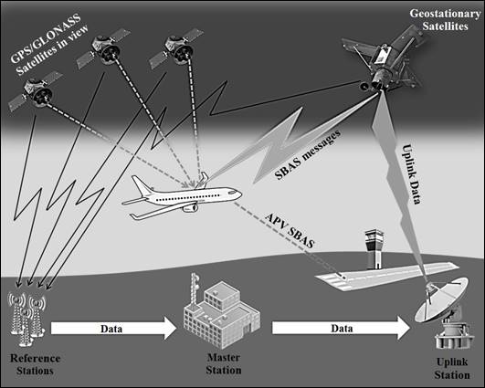
Fig. 1. SBAS architecture
4.2 Remote tower
The main aim of the remote tower concept is to
provide air traffic control services (TWR) or AFIS already provided by a local
aerodrome with tower facilities from a remote location. The aerodrome view will
be captured by cameras and reproduced in the remote tower centre (RTC). The aerodrome
visual imaging can be overlain with information from additional sources (such
as infrared or radar sensors) and enhanced via digital image processing
technology, which will improve controllers’ situational awareness in
low-visibility meteorological conditions (e.g., fog, precipitations).
Obviously, the controllers will also have access to all necessary work tools,
including voice communications (radios, phones), lighting and navigation aid
controls and flight plan/meteorological information-handling systems [25].
The main targets for the SESAR remote tower
concept are small, low-density aerodromes (usually single operations, rarely
exceeding two simultaneous movements) and seasonal tourist airports with
occasional medium traffic density (more than two simultaneous operations),
which today are struggling with low business margins [21]. From a remote tower
location, the remote ATCO/AFISO will be able to provide ATS to one or more
airports and their adjacent airspace at a time. In other words, through centralized
resource pools, remote tower facilities will generate lower maintenance,
staffing and training costs and be able to operate for longer periods.
Additionally, this concept will also result in the significant reduction of the
local control tower’s infrastructure maintenance costs, which will minimize
losses in airport revenue. The remote tower can also be a suitable solution in
case of planned and unplanned contingency events, such as control tower repairs
or emergency situations (fire alarm, bomb threat) [21].
The essence of the SESAR remote tower operating
method is removing local ATCO (TWR or AFISO) working positions from an
aerodrome’s control tower building to an RTC, which will contain several remote
tower modules (RTM), similar to sector positions in an approach or area control
centre. Each RTM will be remotely connected to one or several low density
airports. The ATCO will provide air traffic control services based on an
out-of-the-window view captured by video and infrared cameras deployed in
different parts of the airfield (tower view and/or multiple viewpoints). The
visual reproduction can be overlain with information from additional sources,
such as surface movement radar, surveillance radar, automatic depend
surveillance-broadcast (ADS-B), multilateration or other available positioning,
and surveillance systems. All collected data will be displayed on monitor
screens, projectors or similar technical solutions, which will guarantee a
uniform, smooth and high-quality visual view (see Fig. 2). The visual
reproduction of the aerodrome can be optionally supplemented by airport sound
reproduction (such as engine noise, wind noise etc.). It is worth mentioning
that visual reproduction technology can offer certain benefits compared to the
standard out-the-window view. For example, sensor data from multiple, sometimes
non-optical, sensors (ground-based and aircraft-based) may be fused, analysed
and presented together on the visual reproduction in a way that further
enhances the ATCO/AFISO situational awareness, especially in low-visibility
conditions. The remote tower concept will also introduce the ability to record
visual information, which will create enhanced and unique opportunities to
support incident/accident investigations [21].
Except for the functionalities
mentioned above, the RTM will be equipped with technical functions and systems,
currently found in local facilities, which are necessary to provide services,
such as [21]:
· communications: VHF/UHF radio,
ground radio system, rescue (SAR) radio, telephone, optionally data link
(CPDLC)
· flight plan processing system;
· manoeuvring of ground lighting,
navigation aids, alarms etc.
· signal light gun
· system for reproducing the
“binocular” view, e.g., pan-tilt-zoom camera
· surveillance: radar scope or alternative
solution (multilateration, ADS-B, visual tracking)
The validation exercises performed
at the Angelholm-Helsingborg Aerodrome and Værøy Heliport in
Scandinavia proved that providing ATS remotely is a safe concept. ATCRs
involved in the remote tower validation exercise felt that RTCs, when coupled
with advanced technical enablers, could provide enhanced safety and capacity,
in comparison to the local tower environment, especially in low-visibility
conditions (IFR traffic). Participants also observed that visual reproduction
could potentially lead to limitations, such as the deterioration of ATCO’s
depth perception, which, in some cases, can increase the need to hold and, in
turn, negatively affect the capacity to handle VFR traffic [24].
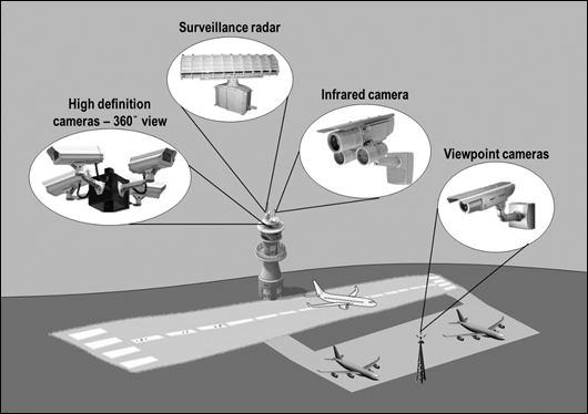
Fig. 2. Airport sensor deployment
5. CONCLUSION
To sum up, the deployment of the
SESAR initiatives’ key technological solutions, such as RNAV (GNSS) approaches
and the remote tower concept, offers, in addition to the undisputed economic
benefits, a significant increase in air traffic safety, especially in small
regional airports’ airspace. In the case of RNAV (GNSS) augmented approaches,
the increase in air operation safety has resulted from providing pilots with
better situational awareness than when using conventional non-precision
approaches, thereby reducing the risk of a controlled flight into terrain.
Almost all SBAS approaches offer vertical guidance down to a decision height of
75 m (250 ft), which is less than the ILS Category I minimum. Another advantage
in implementing RNAV approaches is that it enables better access to airports
that are not equipped with precision approach and landing systems, as well as
airports where precision approach aids are out of service (APV operation backup
solutions in case of ILS outages). Regarding the en-route phase of a flight,
introducing RNAV procedures will help to enable curved approaches and
continuous descent paths, which will reduce the impact of aviation on the
environment (less noise and CO2 emissions). Using SBAS augmented RVAV
approaches will also bring particular benefits for helicopter operations, such
as offshore, mountain rescue and emergency medical services. Realizing a
substantial reduction in the decision height and allowing for approach
procedures to be developed from any direction, RNAV (GNSS) approaches will
improve the safety and accessibility of helipads in poor weather conditions.
In the case of remote tower concept
implementation, the level of air operation safety has been increased by the
ability to use a wide range of aeronautical data from multiple, sometimes
non-optical, sensors (such as surface movement radar, surveillance radar, ADS-B
and multilateration), which will significantly improve ATCO/AFISO situational
awareness, especially in low-visibility (IFR) conditions. The Remote Tower
concept will also introduce the ability to record visual information, which
will create enhanced and unique opportunities to support incident/accident
investigations. Moreover, it can be a suitable solution in the case of planned
and unplanned contingency events, such as control tower repairs or emergency
situations.
References
1.
Air
Transport Action Group. “Aviation Benefits Beyond Borders. European Union”.
2014. Available at: http://aviationbenefits.org/media/26786/ATAG__AviationBenefitsEU2014_FULL_LowRes.pdf.
2.
Air
Transport Action Group. “Aviation Benefits Beyond Borders”. 2014. Available at:
http://aviationbenefits.org/media/26786/ATAG__AviationBenefits2014_FULL_LowRes.pdf.
3.
Annex
10 to the Convention on International Civil Aviation. Aeronautical
Telecommunications. Volume II: Communication Procedures. ICAO, 2008.
4.
Beck
Matthew, David Hensher. 2015. “Finding long-term solutions to financing 21st century
infrastructure needs - a think piece”. Road
& Transport Research: A Journal of Australian and New Zealand Research
and Practice, Vol. 24, Issue 3:
57-61. ISSN: 1037-5783.
5.
European ATM Master Plan. The
Roadmap for Sustainable Air Traffic Management. 2014. Available at: https://www.atmmasterplan.eu/download/29.
6.
Doc
025. EUR RNP APCH Guidance Material.
ICAO, 2012.
7.
Doc
9849. Global Navigation Satellite System
(GNSS) Manual, ICAO, 2005.
8.
European
Commission. “Commission staff working paper on preparing a deployment strategy
for the Single European Sky technological pillar.” 2014. Available at:
http://ec.europa.eu/transport/modes/air/sesar/doc/2010-sec-2010-1580-f.pdf.
9.
European
Commission. “SESAR 2020: developing the next generation of European Air Traffic
Management.” 2014. Available at: http://ec.europa.eu/research/press/jti/factsheet_sesar-web.pdf.
10.
Europa.eu.
“A joint undertaking to develop the new generation European air traffic
management system (SESAR)”. 2014. Available at:
http://europa.eu/legislation_summaries/transport/air_transport/l24459_en.htm.
11.
European
Global Navigation Satellite Systems Agency. “EGNOS for aviation. High
precision, low investment”. 2014. Available at: http://www.gsa.europa.eu/sites/default/files/EGNOSu2013aviation_brochure_update.pdf.
12.
Fellner
Andrzej, Radosław Fellner, Eugeniusz Piechoczek. 2016. “Pre-flight validation
RNAV GNSS approach procedures for EPKT in ‘EGNOS APV Mielec project’”. Scientific Journal of the Silesian
University of Technology. Series Transport. Vol. 9:
37-46. ISSN: 0209-3324.DOI: http://doi.org/10.20858/sjsutst.2016.90.4.
13.
Infrastructure.gov.au.
“Satellite based augmentation system (SBAS) review”. 2014. Available at: http://www.infrastructure.gov.au/aviation/sbas.
14.
Regulation
(EC) 1070/2009 of 21 October 2009, OJ L300, 14 November 2009.
15.
Regulation
(EC) 219/2007 of 27 February 2007, OJ L64, 2 March 2007.
16.
Regulations
(EC) 549/2004, 550/2004, 551/2004, 552/2004, OJ L96, 31 March 2004.
17.
SESAR.
“Airport integration and throughput”. 2014. Available at:
http://www.sesarju.eu/sesar-solutions/airport-integration-and-throughput.
18.
SESAR.
“Approach procedure with vertical guidance (APV)”. 2014. Available at:
http://www.sesarju.eu/sites/default/files/solutions/3_Validation_of_LPV_ATC_Procedures_and_Training_Report.pdf?issuusl=ignore.
19.
SESAR.
“Background on Single European Sky”. 2014. Available at:
http://www.sesarju.eu/discover-sesar/history/background-ses.
20.
SESAR.
“Conflict management and automation”. 2014. Available at:
http://www.sesarju.eu/sesar-solutions/conflict-management-and-automation.
21.
SESAR.
“D02/D04 OSED for remote provision of ATS to aerodromes, including functional
specification”. 2014. Available at:
http://www.sesarju.eu/sites/default/files/solutions/4_Single_Remote_Tower_OSED.pdf?issuusl=ignore.
22.
SESAR.
“Moving from airspace to 4D trajectory management”. 2014. Available at: http://www.sesarju.eu/sesar-solutions/moving-airspace-4d-trajectory-management.
23.
SESAR.
“Network collaborative management and dynamic/capacity balancing”. 2014.
Available at: http://www.sesarju.eu/sesar-solutions/network-collaborative-management-and-dynamiccapacity-balancing.
24.
SESAR.
“Remote provision of ATS to a single aerodrome”. 2014. Available at:
http://www.sesarju.eu/sites/default/files/solutions/3e_Single_Remote_Tower_VALR-Annex.pdf?issuusl=ignore.
25.
SESAR.
“SESAR solution. Single airport remote tower. Contextual note”. Accessed: 1
September 2014. Available at:
http://www.sesarju.eu/sites/default/files/solutions/1_Single_Airport_Remote_Tower_Contextual_note.pdf?issuusl=ignore.
26.
SESAR.
“System Wide Information Management”. 2014. Available at: http://www.sesarju.eu/sesar-solutions/system-wide-information-management.
27.
SESAR.
“Traffic synchronization”. 2014. Available at:
http://www.sesarju.eu/sesar-solutions/traffic-synchronisation.
28.
SESAR.
“WP 15 - Non avionic CNS system description of work (DoW)”. 2014. Available at:
http://www.sesarju.eu/discover-sesar/workpackages-summary.
29.
UASC.
“Operating in satellite-based augmentation system (SBAS) airspace”. 2014.
Available at: https://www.uasc.com/docs/default-source/documents/whitepapers/uasc_sbas_whitepaper.pdf?sfvrsn=2.
Received 28.12.2016;
accepted in revised form 12.02.2017
![]()
Scientific Journal of Silesian University of
Technology. Series Transport is licensed under a Creative Commons
Attribution 4.0 International License