Article
citation information:
Wnorowski, J., Łebkowski, A. Ship
information systems using smartglasses technology. Scientific Journal of Silesian University of Technology. Series
Transport. 2018, 100,
211-222. ISSN: 0209-3324. DOI: https://doi.org/10.20858/sjsutst.2018.100.18.
Jakub WNOROWSKI[1],
Andrzej ŁEBKOWSKI[2]
SHIP
INFORMATION SYSTEMS USING SMARTGLASSES TECHNOLOGY
Summary. New
technology in the maritime sector often forces shipowners to assemble many new
devices on their ship, which can increase the safety of sea travel. With each
additional device on the navigation bridge, there are additional sets of data
that need to be observed. The following article describes one of the
possibilities of using augmented reality technology to support navigational
decisions. The research used “smartglasses” technology and AR
glasses from Meta Glasses.
Keywords: augmented reality; AR technology; navigation bridge.
1. INTRODUCTION
Augmented
reality (AR) is a technology that is consistently gaining more and more users.
Every day, it is used in mobile games and car displays (HUD) and as modern city
guides, where a tablet or smartphone with a suitable application can replace a
book. AR technology usually employs a computer, which processes the image
obtained from the camera, then displays digitally
generated items on
the screen. Nowadays, AR glasses are increasingly used as screens. Currently,
companies are outdoing themselves in the production of smaller and more
comfortable glasses. There are currently models that look similar to ordinary
prescription glasses:
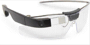
Fig. 1. Google
“Glass” [16]
AR technology is found not only in
the entertainment industry, but also in various professional applications:
·
Healthcare
On daily basis, medical
applications using AR technology can be used to improve our lives. There are
many applications on the market, which, when integrated with additional
devices, e.g., with smart bands, can monitor the pulse, count steps or act as a
personal trainer. AR technology can also be used to indicate the distribution
of public medical devices, e.g., defibrillators [12]
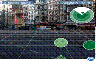
Fig. 2.
Example view from a defibrillator search application [12]
· Aviation
In the aviation sector,
AR technology can be found at every level. From the design stage of aircraft to
management and display devices in pilot cockpits. Starting from modelling the
device in virtual space, you can eliminate later defects. More and more
engineering companies are implementing this kind of solution. In the aviation
sector, one such company is Pratt & Whitney, which not only uses technology
to apply AR in the production of engines, but also to train their mechanics
[21]
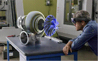
Fig. 3. An engineer visualizes
a mechanical hologram [21]
An interesting solution
for displaying data in the pilot‘s cockpit has been presented by Aero
Glass, using smartglasses technology, Android software and a special board to
recognize the position of the pilot‘s head. Aero Glass can visualize terrain,
navigation traffic, instrument, weather and airspace information with access to
vital safety procedures and protocols [22].

Fig. 4. View through Aero
Glass smartglasses [22]
· Transit systems
The best example of the
use of AR technology in road transport can be found in various smart GPS
concepts. For example, Sygic has created its own application using the GPS
module of a mobile phone and a camera for positioning digital elements on a
real image. In turn, the driver does not have to focus on reading the map.
Instead, they follow a virtual path in the preview of the smartphone‘s
camera (Figure 5) [23].
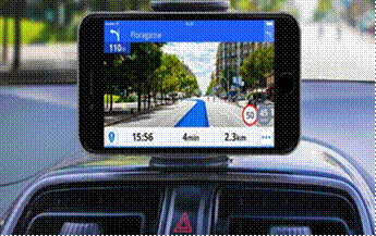
Fig. 5. Sygic AR GPS [23]
Another intelligent GPS
approach has been proposed by WayRay. Instead of using phones, the company
decided to display data, such as the trajectory of a car’s movement or
the speed on the car‘s windshield. There is also an option to display
information on the glass about restaurants, pubs, street names etc. (Figure 6)
[24].
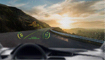
Fig. 6. WayRay AR GPS [24]
·
Maritime sector
AR technology in the maritime sector has
appeared relatively recently, but it is growing rapidly. One of the companies
dealing with this technology is a company that every seafarer knows - MarineTraffic.
The company has created an application that uses a smartphone magnetometer to
orient the device relative to the earth‘s magnetic field. On this basis,
any information about vessels, ports and light signs near the device are
displayed [20].
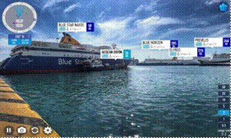
Fig. 7.
MarineTraffic’s mobile application [20]
Another example of an application using AR technology has recently been
presented by Japan’s Mitsui O.S.K. Lines and Furuno Electric Co. These
two companies decided to jointly develop an application that displays every
piece of important information based on data from AIS. Japan’s Mitsui
O.S.K. Lines announced that it would like to combine this application with data
obtained from radars and implement algorithms for avoiding collisions [27].
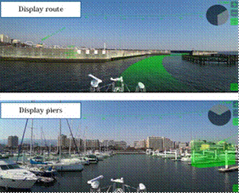
Fig. 7. Application from
Japan‘s Mitsui O.S.K. Lines and Furuno Electric
Co. [27]
2. AUGMENTED REALITY BRIDGE SYSTEM
Currently,
the navigation bridge is built in such a way that all relevant devices are
spread out, so that the navigator has to walk from one side to the other to
read the necessary information.
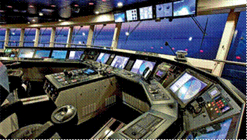
Fig. 8.
Example of a navigation bridge [9]
Using AR
technology, we are able to display all information in one place. Moreover, the navigation
officer does not have to be directly on the navigation bridge to read the data.
·
Head-up display
One of the first projects to display
navigational data on the navigating bridge panes was proposed by a team of
researchers from the Japanese Institute of Navigation, led by Kenjiro Hikida.
They presented a transparent screen on which they displayed data such as object
names, headings and distances between objects and speed [3].
One of the
companies that has presented its own decision support system using AR is
Rolls-Royce. This system displays necessary information on a specially crafted
bridge window, including parameters of passing objects, data on
hydrometeorological conditions, digital map projections or the distance to
nearby objects. Some of the information provided can be displayed
three-dimensionally. This future bridge project is shown in Figures 10 and 11:
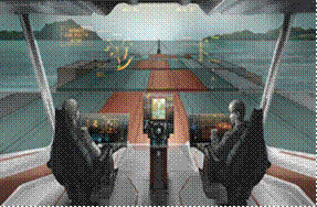
Fig. 9. The concept of the
navigation bridge from Rolls-Royce (1) [9]
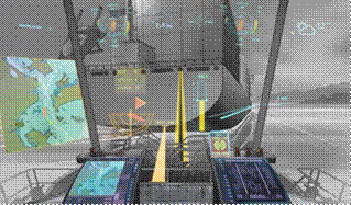
Fig. 10. The concept of the
navigation bridge from Rolls-Royce (2) [9]
The above solution
looks interesting, but the modernization of the existing bridge would be
extremely costly. The second aspect of this solution is that the visibility of
data in full sunlight cannot be determined. All visualizations are made for a
dark background, so it seems that even the creators have predicted that, in the
light of day, this solution will not work.
In order to reduce the possible
costs related to the bridge reconstruction, Meta Glasses’ glasses were
used for the research. Thanks to the use of these glasses, we do not need to
get rid of the devices from navigation bridge. This alone introduces the
redundancy of the device, which is very important. In addition, the eyewear
operator has access to all data from anywhere on the ship.
·
AR glasses
The first device
using AR technology was presented by Ivan Sutherland in the 1960s at Harvard
University. He called it the “Sword of Damocles”. It was used to
display the grid under the user [15]. In 2000, Daniel Wagner and Dieter
Schmalstieg created the first library enabling the creation of applications
that used AR on mobile phones. Given this invention, the popularity of AR began
to grow [15].
The first AR glasses were released in 2014
by Google. While this made AR available to everyone, the project quickly
collapsed because the glasses were found to be uncomfortable. That said, in
subsequent years, companies producing AR glasses have started to come into
existence. One of these companies is Meta Glasses, which has created the
“Meta 1” and “Meta 2” glasses. Thanks to the developer
versions of these glasses, the creation of a highly advanced application using
AR has become possible for ordinary people [15].
3. SMARTGLASSES SYSTEM
During the
creation of the research system, the following design assumptions were adopted:
·
The application should process real-time
data retrieved from the AIS device, then create a graphical representation
based on them.
·
The user should be able to interact with
objects using hand movements, hand gestures and voice commands.
·
The user should have a full 360° field
of view; however, the object is displayed depending of the current direction in
which the head of the operator is turned.
·
The application should allow for
observation around the ship, even when the user is not on the navigation
bridge.
In order to examine the possibility of using AR
technology on ship, a set of AR glasses from Meta Glasses and the “Unity
3D” game engine were used. The AIS device used for communication referred
to the NMEA0183 standard. Serial communication, with the program written in C#
language, was used to read the AIS information. Next, the information was
decoded and transferred to the main part of program. The system schematic is as
presented in Figure 12.
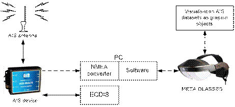
Fig. 12. Simple system
schematic
Each geographic
coordinate read from the AIS device has been transformed from a geographic
coordinate system (Lat, Long) into a Cartesian coordinate system (x,y), using
the following mathematical functions:
|
|
(1) |
|
|
(2) |
|
|
(3) |

In order to automate the conversion
of the geographic coordinates into Cartesian ones, the following functions were
written in C#:
public void LatLongToPixelXY(double
latitude, double longitude, double levelofDetail, out intpixelX, out int
pixelY)
{
Latitude=Clip(latitude,MinLatitude,MaxLatitude);
Longitude=Clip(longitude,MinLongitude,MaxLongitude);
X=(longitude+180)/360;
sinLatitude=Math.Sin(latitude*Math.PI/180);y=0.5-Math.Log((1+sinLatitude)/(1- sinLatitude))/(4*Math.PI);
mapSize=MapSize(levelofDetails);
pixelX=(int)Clip(x*mapSize+0.5,0,mapSize-1);
pixelY=(int)Clip(y*mapSize+0.5,0,mapSize-1);
}
private uint MapSize(double levelOfDetail)
{
return
(uint)(256*Math.Pow(2,levelOfDetail));
}
private double Clip(double n, double
minValue, double maxValue)
{
return
Math.Min(Math.Max(n,minValue),maxValue);
}
The above code is used
to transform geographic coordinates into Cartesian one for Mercador mapping,
which is used in marine navigation systems. This is open-source code, which can
be found on the Microsoft website [11]. After receiving the Cartesian
coordinates, 3D objects imitating ships were placed in the appropriate places.
Each object stored information about the MMSI number, geographic coordinates,
speed and course of the vessel. A general diagram for the software algorithm is
shown in Figure 13.
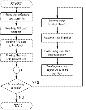
Fig. 13. Software
algorithm
Example scenes from the application
are shown in Figures 14-15.
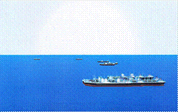
Fig. 14. An example view
of the navigational situation using AR Goggles
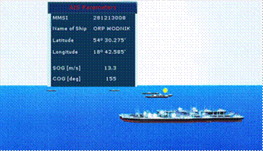
Fig. 15. Window with the
parameters of the indicated vessel in the AR display system
4.
CONCLUSION
The use of glasses
together with AR technology as a tool for decision support systems seems to be
a good starting point when it comes to using AR on ships for the following
reasons:
·
The proposed system does not involve
significant costs.
·
A lot of information can be displayed on
very small area using gesture and voice commands.
·
Redundancy of navigation devices
·
Wide prospects for system expansion.
Regarding
the latter, it is possible to easily expand the system with further interfaces
with new data sets. Thanks to the use of AR glasses, it is possible to display
a 3D cross-section of objects, e.g., the course of the seabed, which would
greatly help navigators on offshore ships.
References
1.
Gierusz W. 2015. “Simulation model of the LNG carrier with podded
propulsion. Part 1: Forces generated by pods”. Ocean Engineering 108: 105-114. DOI: 10.1016/j.oceaneng.2015.07.031.
2.
Gierusz W. 2006. “Logic thrust
allocation applied to multivariable control of the training ship”. Control Engineering 14(5): 511-524. DOI:
10.1016/j.conengprac.2005.03.005.
3.
Hikida K. 2010. Development of a Shipboard Visual Lookout Support System with Head-up
Display. Tokyo: Navigation System Research Group, Navigation and Logistics
Engineering Department, National Maritime Research Institute.
4.
Lisowski J. 2012.
“The optimal and safe ship trajectories for different forms of neural
state constraints”. Mechatronic
Systems, Mechanics and Materials. Book series: Solid State Phenomena 18/0: 64-69. DOI:
10.4028/www.scientific.net/SSP.180.64.
5.
Lisowski J. 2012.
“Game control methods in avoidance of ships collisions”. Polish Maritime Research 19(1): 3-10.
DOI: 10.2478/v10012-012-0016-4.
6.
Lisowski J. 2013.
“Sensitivity of Computer Support Game Algorithms of Safe Ship
Control”. International Journal of
Applied Mathematics and Computer Science 23 (2): 439-446. DOI:
10.2478/amcs-2013-0033.
7.
Lisowski J. 2014.
“Computational intelligence methods of a safe ship control”. In XVIII Annual Conference KES-2014
“Knowledge-Based and Intelligent Information & Engineering
Systems”: 634-643. DOI: 10.1016/j.procs.2014.08.145.
8.
Moseley K. 2017. “Global smart
glasses market 2017 - Google Glass, Carl Zeiss, Vuzix and Sony”.
Available at: http://www.freenewsman.com.
9.
Wartsila SAM Electronics.
“Navigation”. Available at: http://www.samelectronics.de.
10.
The Maritime Executive, Rolls-Royce.
“VTT Unveil Vision of Ship Intelligence”. Available at: http://www.maritime-executive.com.
11.
Schwartz J. “Bing Maps tile
system”. Available at:
http://msdn.microsoft.com/en-us/library/bb259689.aspx.
12.
The Medical Futurist Institute. “The
top 9 augmented reality companies in healthcare”. Available at:
http://medicalfuturist.com/top-9-augmented-reality-companies-healthcare.
13.
Shukla A. “IAF order worth Rs 250
crores to Indian industry: Samtel cockpit displays cleared for the Su-30
MKI”. Available at:
http://ajaishukla.blogspot.com/2010/10/iaf-order-worth-rs-250-crores-to-indian.html.
14.
Sygic.
“Sygic incorporates augmented reality into its GPS navigation
app”. Available at: http://www.sygic.com/.
15.
Charara S., L. Prasuethsut.
“Everything you need to know about augmented reality: then, now &
next”. Available at: http://www.wareable.com.
16.
Meta, SDK 2.5.0 Release Notes. Available
at: http://www.metavision.com.
17.
Proceedings
of the 17th DASC. AIAA/IEEE/SAE. Digital Avionics Systems Conference (Cat.
no. 98CH36267). Bellevue, WA. 31 October-7 November 1998. IEEE.
18.
Yoon, C., K. Kim,, S. Baek, S.Y. Park. 2014. “Development
of augmented in-vehicle navigation system for head-up display”. In 2014 International Conference on Information
and Communication Technology Convergence (ICTC): 601-602. Busan, South
Korea. 22-24 October 2014. IEEE. DOI: 10.1109/ICTC.2014.6983221.
19.
Yoon C., K. Kim, H.S. Park, M.W. Park,
S.K. Jung. 2014. “Development of augmented forward collision warning
system for head-up display”. In 17th
International IEEE Conference on Intelligent Transportation Systems (ITSC):
2277-2279. Qingdao, China. 8-11 October 2014. IEEE. DOI:
10.1109/ITSC.2014.6958054.
20.
MarineTraffic. “Use the augmented
reality tool”. Available at: http://www.marinetraffic.com.
21.
Woodrow B. “9 companies using
augmented and virtual reality in aviation”. Available at:
http://www.aviationtoday.com.
22.
Glass Aero. “Join the augmented reality revolution in aviation!”. Available at:
https://glass.aero.
23.
GPS World Staff. “Sygic incorporates
augmented reality into GPS navigation app”. Available at:
http://gpsworld.com.
24.
GPS World Staff. “WayRay offers
holographic navigation system for car”. Available at:
http://gpsworld.com.
25.
Startupticker. “Alibaba invests in
WayRay”. Available at: https://www.startupticker.ch.
26.
ThinkMobiles. “25 best augmented
reality games 2017 for Android and iOS”. Available at:
https://thinkmobiles.com.
27.
MarineLog. 2017. “MOL and Furuno to
develop Augmented Reality enhanced displays”. Available at: http://www.marinelog.com.
28.
Babu
D., I.M.V.L.R. A. Sidhardhan. 2017. “Effects of intra-household
interactions on travel behaviour of working people: a study of Calicut city,
India”. European
Transport/Trasporti Europei 66(4).
Received 21.03.2018; accepted in revised form 30.08.2018
![]()
Scientific
Journal of Silesian University of Technology. Series Transport is licensed
under a Creative Commons Attribution 4.0 International License